
Eastern Equatoria topographic map
Interactive map
Click on the map to display elevation.
About this map
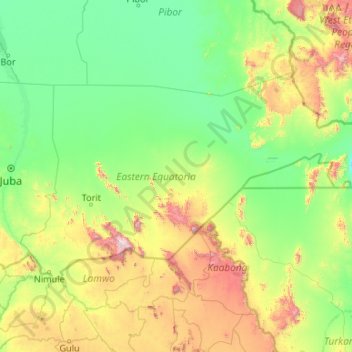
Name: Eastern Equatoria topographic map, elevation, terrain.
Location: Eastern Equatoria, South Sudan (3.50479 31.70711 6.00728 35.94900)
Average elevation: 730 m
Minimum elevation: 378 m
Maximum elevation: 3,085 m
Other topographic maps
Click on a map to view its topography, its elevation and its terrain.
Kapoeta
South Sudan > Eastern Equatoria > Kapoeta South
The town lies on the east bank of the Singaita River. The post at Kapoeta was established by Captain Knollys, who reached the river in January 1927. This location lies approximately 275 kilometres (171 mi), by road, east of Juba, the capital of South Sudan, and the largest city in that country. The town sits…
Average elevation: 671 m