Geolocate

High Roding topographic map

Click on the map to display elevation.

About this map

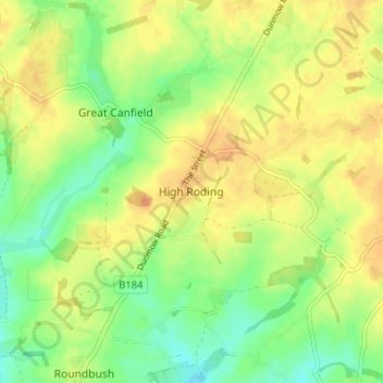
Name: High Roding topographic map, elevation, terrain.

Location: High Roding, Uttlesford, Essex, England, CM6 1YH, United Kingdom (51.81016 0.30609 51.85016 0.34609)

Average elevation: 79 m

Minimum elevation: 61 m

Maximum elevation: 93 m

Other topographic maps

Click on a map to view its topography, its elevation and its terrain.

Hadstock

United Kingdom > England > Essex > Uttlesford > Hadstock

Average elevation: 81 m

Coles Green

United Kingdom > England > Essex > Uttlesford > Berden > Little London

Average elevation: 100 m

Great Chesterford

United Kingdom > England > Essex > Uttlesford

Average elevation: 58 m

Henham

United Kingdom > England > Essex > Uttlesford

Average elevation: 104 m

Berden

United Kingdom > England > Essex > Uttlesford > Berden

Average elevation: 104 m

Little Bardfield

United Kingdom > England > Essex > Uttlesford

Average elevation: 90 m

Little Easton

United Kingdom > England > Essex > Uttlesford > Little Easton

Living in the parish were Lord and Lady Brooke, the later Earl and Countess of Warwick, at Easton Lodge, who were also resident at Berwick House in the Stable Yard of St James's Palace, London, and in 1902, after elevation to title, Warwick Castle. Parish occupations in 1882 included three farmers, one of whom…

Average elevation: 88 m

Debden

United Kingdom > England > Essex > Uttlesford > Debden

Average elevation: 108 m

Great Easton

United Kingdom > England > Essex > Uttlesford > Great Easton

Average elevation: 85 m

Clavering

United Kingdom > England > Essex > Uttlesford > Clavering

Average elevation: 108 m

Newport

United Kingdom > England > Essex > Uttlesford > Newport

Average elevation: 82 m

Wendens Ambo

United Kingdom > England > Essex > Uttlesford > Wendens Ambo

Average elevation: 81 m

Elsenham

United Kingdom > England > Essex > Uttlesford > Elsenham

Average elevation: 102 m

Littlebury

United Kingdom > England > Essex > Uttlesford > Littlebury

Average elevation: 78 m

Birchanger

United Kingdom > England > Essex > Uttlesford > Birchanger

Average elevation: 85 m

Little Hallingbury

United Kingdom > England > Essex > Uttlesford

Average elevation: 69 m

Broxted

United Kingdom > England > Essex > Uttlesford > Broxted

Average elevation: 100 m

Hempstead

United Kingdom > England > Essex > Uttlesford > Hempstead

Average elevation: 101 m

Little Hallingbury

United Kingdom > England > Essex > Uttlesford

Average elevation: 69 m

Gear up for your next adventure:

🧣Merino Neck Gaiters - Versatile headwear for warmth, sun protection, or dust filtering
🪑Portable Backpacking Chairs - A comfortable seat for studying maps at the end of the day
🖼️Scratch-off Australia Map - Track the regions and peaks you have explored geographically
🧭Military Style Lensatic Compass - Durable sighting compasses for advanced land navigation and surveying
🔌Fast Charging Adapters - Quickly top up all your gear before heading back into the field

As an Amazon Associate, this site earns from qualifying purchases at no extra cost to you.