
Mount Ellsworth topographic map
Interactive map
Click on the map to display elevation.
About this map
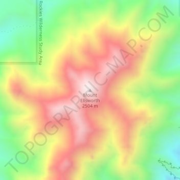
Name: Mount Ellsworth topographic map, elevation, terrain.
Location: Mount Ellsworth, Garfield County, Utah, VS (37.74605 -110.61992 37.74615 -110.61982)
Average elevation: 2,111 m
Minimum elevation: 1,707 m
Maximum elevation: 2,504 m
Other topographic maps
Click on a map to view its topography, its elevation and its terrain.
Zion National Park
Zion National Park, West Rim Trail, Washington County, Utah, VS
Average elevation: 1,877 m
Capitol Reef National Park
Capitol Reef National Park, Notom To Oak Creek Road, Garfield County, Utah, VS
Average elevation: 1,963 m
Canyonlands National Park
Canyonlands National Park, Wayne County, Utah, VS
Average elevation: 1,640 m