Geolocate

Sandia topographic map

Interactive map

Click on the map to display elevation.

About this map

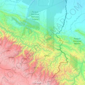
Name: Sandia topographic map, elevation, terrain.

Location: Sandia, Puno, 21101, Perú (-14.66193 -69.84857 -13.00413 -68.82668)

Average elevation: 1,709 m

Minimum elevation: 191 m

Maximum elevation: 6,008 m

Other topographic maps

Click on a map to view its topography, its elevation and its terrain.

Isivilla

Perú > Puno > Corani

Isivilla, Corani, Carabaya, Puno, Perú

Average elevation: 4,393 m

Macusani

Perú > Puno > Macusani

Macusani, Carabaya, Puno, Perú

Average elevation: 4,508 m

Mañazo

Perú > Puno

Mañazo, Puno, Perú

Average elevation: 4,318 m

Corani

Perú > Puno

Corani, Carabaya, Puno, Perú

Average elevation: 4,536 m

Aymaña

Perú > Puno > Corani

Aymaña, Corani, Carabaya, Puno, Perú

Average elevation: 4,396 m

Juliaca

Perú > Puno

Juliaca, San Román, Puno, Perú

Average elevation: 3,863 m