
Macquarie Island topographic map
Interactive map
Click on the map to display elevation.
About this map
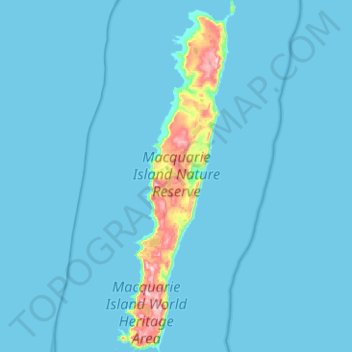
Name: Macquarie Island topographic map, elevation, terrain.
Location: Macquarie Island, Huon Valley, Tasmania, Australia (-54.77699 158.77815 -54.48663 158.94701)
Average elevation: 20 m
Minimum elevation: 0 m
Maximum elevation: 395 m
Macquarie Island is about 34 km (21 mi) long and 5 km (3 mi) wide, with an area of 128 km2 (49 sq mi). The island consists of plateaus at north and south ends, each of 150–200 m (490–660 ft) elevation, joined by a low, narrow isthmus. The high points include Mount Elder on the north-east coastal ridge at 385 m (1,263 ft), and Mounts Hamilton and Fletcher in the south at 410 m (1,345 ft). The island is almost equidistant between the island of Tasmania and the Antarctic continent's Anderson Peninsula (about 1,500 km (930 mi) to either point). In addition, Macquarie Island is about 630 km (390 mi) south-west of Auckland Island, and 1,300 km (810 mi) north of the Balleny Islands.
Other topographic maps
Click on a map to view its topography, its elevation and its terrain.
Cradle Mountain
Australia > Tasmania > Cradle Mountain
Cradle Mountain, Cradle Mount Summit Track, Cradle Mountain, Meander Valley, Tasmania, Australia
Average elevation: 1,144 m
Launceston
Australia > Tasmania > Launceston
Launceston, Tasmania, 7250, Australia
Average elevation: 218 m
West Kentish
West Kentish, Kentish, Tasmania, 7306, Australia
Average elevation: 291 m
Mount Lloyd
Mount Lloyd, Derwent Valley, Tasmania, 7140, Australia
Average elevation: 558 m
West Ulverstone
Australia > Tasmania > Ulverstone
West Ulverstone, Ulverstone, Central Coast, Tasmania, 7315, Australia
Average elevation: 26 m
Connellys Marsh
Connellys Marsh, Sorell, Tasmania, 7173, Australia
Average elevation: 41 m
Mount Direction
Mount Direction, Hobart, City of Clarence, Tasmania, 7017, Australia
Average elevation: 166 m
Styx River
Australia > Tasmania > Westerway
Styx River, Westerway, Derwent Valley, Tasmania, Australia
Average elevation: 548 m
West Montagu
West Montagu, Circular Head, Tasmania, 7330, Australia
Average elevation: 35 m
Bruny Island
Australia > Tasmania > Alonnah
Bruny Island, Alonnah, Kingborough, Tasmania, Australia
Average elevation: 59 m
Arthurs Lake
Arthurs Lake, Central Highlands, Tasmania, 7030, Australia
Average elevation: 910 m
Garden Island Creek
Garden Island Creek, Huon Valley, Tasmania, 7112, Australia
Average elevation: 153 m
Lower Turners Marsh
Lower Turners Marsh, City of Launceston, Tasmania, 7267, Australia
Average elevation: 141 m
Launceston
Launceston, City of Launceston, Tasmania, Australia
Average elevation: 194 m
Lower Longley
Lower Longley, Hobart, Kingborough, Tasmania, 7109, Australia
Average elevation: 338 m
Greens Beach
Greens Beach, West Tamar, Tasmania, 7270, Australia
Average elevation: 30 m
Launceston
Launceston, City of Launceston, Tasmania, 7250, Australia
Average elevation: 26 m
Claude Road
Claude Road, Kentish, Tasmania, 7306, Australia
Average elevation: 444 m
Black Hills
Black Hills, Derwent Valley, Tasmania, 7140, Australia
Average elevation: 432 m
Chain Of Lagoons
Chain Of Lagoons, Break O'Day, Tasmania, 7215, Australia
Average elevation: 154 m
Deddington
Deddington, Northern Midlands, Tasmania, 7212, Australia
Average elevation: 358 m
Selfs Point
Selfs Point, New Town, Hobart, City of Hobart, Tasmania, 7008, Australia
Average elevation: 17 m
Mount Wellington
Mount Wellington, City of Hobart, Tasmania, Australia
Average elevation: 941 m
Lake Murchison
Australia > Tasmania > Tullah > Lake St Clair
Lake Murchison, Lake St Clair, Tullah, West Coast, Tasmania, Australia
Average elevation: 531 m
Lower Barrington
Lower Barrington, Kentish, Tasmania, 7306, Australia
Average elevation: 202 m