
Devils Knob topographic map
Click on the map to display elevation.
About this map
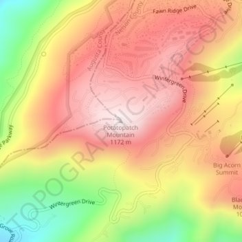
Name: Devils Knob topographic map, elevation, terrain.
Location: Devils Knob, Nelson County, Virginia, 29952, United States (37.91620 -78.95480 37.91630 -78.95470)
Average elevation: 939 m
Minimum elevation: 599 m
Maximum elevation: 1,172 m
Other topographic maps
Click on a map to view its topography, its elevation and its terrain.
Great Falls
United States > Virginia > Fairfax County > Great Falls
Great Falls is located at 38°59′53″N 077°17′18″W / 38.99806°N 77.28833°W / 38.99806; -77.28833 (38.9981653, −77.2883157) at an elevation of 344 feet (105 m). Located on Virginia State Route 7 in Northern Virginia, Great Falls is 15 miles (24 km) west-northwest of downtown Washington,…
Average elevation: 88 m
Vinton
United States > Virginia > Roanoke County
Vinton has varied topography, considering its 3.2 square mile size. The above-mentioned lake is at an elevation of 890 feet (270 m) above sea level. The Vinton side of the lake consists of a steep, wooded cliff 150 feet (46 m) in vertical height. Vinton's highest point is on Olney Road, at an elevation of…
Average elevation: 305 m
Wolf Trap National Park for the Performing Arts
United States > Virginia > Fairfax County > Wolf Trap > Shouse Village
Average elevation: 104 m
Kernstown Battlefield Park
United States > Virginia > Frederick County > Winchester > Valley Acres
Average elevation: 241 m
Barboursville Community Park
United States > Virginia > Orange County > Barboursville
Average elevation: 158 m
Robious Landing Park
United States > Virginia > Chesterfield County > Midlothian
Average elevation: 55 m
Painter
United States > Virginia > Accomack County
It lies at an elevation of 36 feet.
Average elevation: 10 m