
Malappuram topographic map
Interactive map
Click on the map to display elevation.
About this map
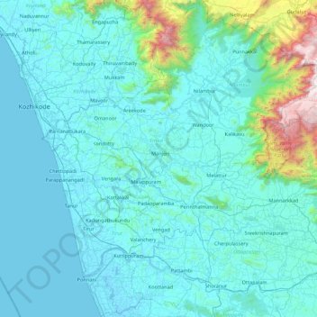
Name: Malappuram topographic map, elevation, terrain.
Location: Malappuram, Kerala, India (10.68412 75.82559 11.52928 76.54926)
Average elevation: 224 m
Minimum elevation: -5 m
Maximum elevation: 2,529 m
On the basis of topography, geology, soils, climate, and natural vegetation, the district is divided into 5 sub-micro regions:
Other topographic maps
Click on a map to view its topography, its elevation and its terrain.
Tholpetty
India > Kerala > Mananthavady
Tholpetty, Mananthavady, Wayanad District, Kerala, 571250, India
Average elevation: 875 m
Thrikkunnapuzha
India > Kerala > Karthikappally
Thrikkunnapuzha, Karthikappally, Alappuzha District, Kerala, 690516, India
Average elevation: 2 m
Vallapuzha
Vallapuzha, Pattambi, Palakkad District, Kerala, 679335, India
Average elevation: 56 m
Kolayi Waterfall
India > Kerala > Ernad > Malappuram
Kolayi Waterfall, MAADIN COLLEGE ROAD, Malappuram, Ernad, Malappuram, Kerala, 676517, India
Average elevation: 67 m
Malayattoor
India > Kerala > Malayattoor
Malayattoor, Ernakulam, Kerala, KERALA 683544, India
Average elevation: 51 m
Kanjirappalli
India > Kerala > Kanjirappally > Kanjirappalli
Kanjirappalli, Kanjirappally, Kottayam, Kerala, 686507, India
Average elevation: 83 m
Idappadi (edappady)
India > Kerala > Meenachil > Idappadi (edappady)
Idappadi (edappady), Meenachil, Kottayam, Kerala, 686578, India
Average elevation: 44 m
Palott palli
India > Kerala > Thalassery > Palott palli
Palott palli, Thalassery, Kannur district, Kerala, 60702, India
Average elevation: 57 m
Kalamassery
India > Kerala > Kanayannur
Kalamassery, Kanayannur, Ernakulam District, Kerala, 683104, India
Average elevation: 9 m
Kuttippuram
India > Kerala > Kuttippuram
Kuttippuram, Malappuram, Kerala, India
Average elevation: 20 m
Kothamangalam
India > Kerala > Kothamangalam
Kothamangalam, Ernakulam, Kerala, 686691, India
Average elevation: 34 m
Meesapulimala
Meesapulimala, Idukki, Kerala, 685618, India
Average elevation: 2,221 m
Western Ghats
Western Ghats, Idukki, Kerala, 685614, India
Average elevation: 2,225 m
Puthuppally
Puthuppally, Kottayam, Kottayam District, Kerala, 686011, India
Average elevation: 17 m