
Make a donation
Gear up for your next adventure:
As an Amazon Associate, this site earns from qualifying purchases at no extra cost to you.
Wherstead topographic map
Click on the map to display elevation.
Make a donation
Gear up for your next adventure:
As an Amazon Associate, this site earns from qualifying purchases at no extra cost to you.
About this map
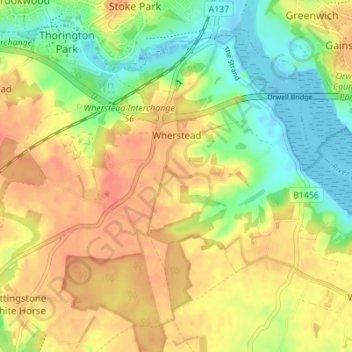
Name: Wherstead topographic map, elevation, terrain.
Location: Wherstead, Babergh, Suffolk, England, United Kingdom (51.99949 1.10193 52.03522 1.17071)
Average elevation: 26 m
Minimum elevation: -3 m
Maximum elevation: 48 m
Make a donation
Gear up for your next adventure:
As an Amazon Associate, this site earns from qualifying purchases at no extra cost to you.
Other topographic maps
Click on a map to view its topography, its elevation and its terrain.
Constable 'The Haywain' viewing point
United Kingdom > England > Suffolk > Babergh > East Bergholt > Flatford
Average elevation: 15 m
Make a donation
Gear up for your next adventure:
As an Amazon Associate, this site earns from qualifying purchases at no extra cost to you.
Make a donation
Gear up for your next adventure:
As an Amazon Associate, this site earns from qualifying purchases at no extra cost to you.
Make a donation
Gear up for your next adventure:
As an Amazon Associate, this site earns from qualifying purchases at no extra cost to you.
Flatford
United Kingdom > England > Suffolk > Babergh > East Bergholt > Flatford
Average elevation: 22 m
Long Melford-Bury St Edmunds branch line
United Kingdom > England > Suffolk > Babergh > Lavenham
Average elevation: 70 m
Mill Green
United Kingdom > England > Suffolk > Babergh > Edwardstone > Mill Green
Average elevation: 59 m
Make a donation
Gear up for your next adventure:
As an Amazon Associate, this site earns from qualifying purchases at no extra cost to you.