
Shotley Gate topographic map
Interactive map
Click on the map to display elevation.
About this map
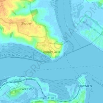
Name: Shotley Gate topographic map, elevation, terrain.
Location: Shotley Gate, Babergh, Suffolk, England, IP9 1QD, United Kingdom (51.93791 1.24862 51.97791 1.28862)
Average elevation: 4 m
Minimum elevation: -6 m
Maximum elevation: 28 m
Other topographic maps
Click on a map to view its topography, its elevation and its terrain.
Layham
United Kingdom > England > Suffolk > Babergh
Layham, Babergh, Suffolk, England, United Kingdom
Average elevation: 41 m
Brent Eleigh
United Kingdom > England > Suffolk > Babergh
Brent Eleigh, Babergh, Suffolk, England, United Kingdom
Average elevation: 64 m
Tattingstone
United Kingdom > England > Suffolk > Babergh
Tattingstone, Babergh, Suffolk, England, United Kingdom
Average elevation: 32 m
River Brett
United Kingdom > England > Suffolk > Babergh
River Brett, Babergh, Suffolk, England, United Kingdom
Average elevation: 59 m
Constable 'The Haywain' viewing point
United Kingdom > England > Suffolk > Babergh > East Bergholt > Flatford
Constable 'The Haywain' viewing point, Flatford Road, Flatford, East Bergholt, Babergh, Suffolk, England, CO7 6UJ, United Kingdom
Average elevation: 15 m
Sudbury
United Kingdom > England > Suffolk > Babergh
Sudbury, Babergh, Suffolk, England, CO10 1GL, United Kingdom
Average elevation: 54 m
Thorpe Morieux
United Kingdom > England > Suffolk > Babergh
Thorpe Morieux, Babergh, Suffolk, England, United Kingdom
Average elevation: 83 m
Little Wenham
United Kingdom > England > Suffolk > Babergh
Little Wenham, Babergh, Suffolk, England, CO7 6PZ, United Kingdom
Average elevation: 46 m
Bentley
United Kingdom > England > Suffolk > Babergh
Bentley, Babergh, Suffolk, England, United Kingdom
Average elevation: 37 m
Milden
United Kingdom > England > Suffolk > Babergh
Milden, Babergh, Suffolk, England, United Kingdom
Average elevation: 69 m
Holbrook
United Kingdom > England > Suffolk > Babergh
Holbrook, Babergh, Suffolk, England, United Kingdom
Average elevation: 19 m
Hartest
United Kingdom > England > Suffolk > Babergh
Hartest, Babergh, Suffolk, England, United Kingdom
Average elevation: 83 m
Dedham Vale AONB
United Kingdom > England > Suffolk > Babergh
Dedham Vale AONB, Babergh, Suffolk, England, United Kingdom
Average elevation: 44 m
Cattawade
United Kingdom > England > Suffolk > Babergh
Brantham, Cattawade, Babergh, Suffolk, England, United Kingdom
Average elevation: 17 m
Stoke-by-Nayland
United Kingdom > England > Suffolk > Babergh
Stoke-by-Nayland, Babergh, Suffolk, England, United Kingdom
Average elevation: 38 m
Wenham Magna
United Kingdom > England > Suffolk > Babergh
Wenham Magna, Little Wenham, Babergh, Suffolk, England, United Kingdom
Average elevation: 48 m
Leavenheath
United Kingdom > England > Suffolk > Babergh
Leavenheath, Babergh, Suffolk, England, United Kingdom
Average elevation: 58 m
Somerton
United Kingdom > England > Suffolk > Babergh
Somerton, Babergh, Suffolk, England, United Kingdom
Average elevation: 83 m
Polstead
United Kingdom > England > Suffolk > Babergh
Polstead, Babergh, Suffolk, England, United Kingdom
Average elevation: 53 m
Lindsey
United Kingdom > England > Suffolk > Babergh
Lindsey, Babergh, Suffolk, England, United Kingdom
Average elevation: 61 m
East Bergholt
United Kingdom > England > Suffolk > Babergh
East Bergholt, Babergh, Suffolk, England, United Kingdom
Average elevation: 27 m
Hitcham
United Kingdom > England > Suffolk > Babergh
Hitcham, Babergh, Suffolk, England, United Kingdom
Average elevation: 77 m
Newton
United Kingdom > England > Suffolk > Babergh
Newton, Babergh, Suffolk, England, United Kingdom
Average elevation: 61 m
Mill Green
United Kingdom > England > Suffolk > Babergh > Edwardstone > Mill Green
Mill Green, Edwardstone, Babergh, Suffolk, East of England, England, CO10 5PY, United Kingdom
Average elevation: 59 m
Long Melford-Bury St Edmunds branch line
United Kingdom > England > Suffolk > Babergh > Lavenham
Long Melford-Bury St Edmunds branch line, Lavenham, Babergh, Suffolk, East of England, England, CO10 9TT, United Kingdom
Average elevation: 70 m
Glemsford
United Kingdom > England > Suffolk > Babergh
Glemsford, Babergh, Suffolk, England, United Kingdom
Average elevation: 58 m
Long Melford
United Kingdom > England > Suffolk > Babergh
Long Melford, Babergh, Suffolk, England, United Kingdom
Average elevation: 59 m
Cockfield
United Kingdom > England > Suffolk > Babergh
Cockfield, Babergh, Suffolk, England, United Kingdom
Average elevation: 85 m
Elmsett
United Kingdom > England > Suffolk > Babergh
Elmsett, Babergh, Suffolk, England, United Kingdom
Average elevation: 63 m
Hadleigh
United Kingdom > England > Suffolk > Babergh
Hadleigh, Babergh, Suffolk, England, United Kingdom
Average elevation: 51 m
Great Cornard
United Kingdom > England > Suffolk > Babergh
Great Cornard, Babergh, Suffolk, England, United Kingdom
Average elevation: 42 m
Shelley
United Kingdom > England > Suffolk > Babergh
Shelley, Babergh, Suffolk, England, United Kingdom
Average elevation: 32 m
Shotley Gate
United Kingdom > England > Suffolk > Babergh
Shotley, Shotley Gate, Babergh, Suffolk, England, United Kingdom
Average elevation: 10 m
Flatford
United Kingdom > England > Suffolk > Babergh > East Bergholt > Flatford
Flatford, East Bergholt, Babergh, Suffolk, East of England, England, CO7 6UL, United Kingdom
Average elevation: 22 m
Brettenham
United Kingdom > England > Suffolk > Babergh
Brettenham, Babergh, Suffolk, England, United Kingdom
Average elevation: 83 m
Chelmondiston
United Kingdom > England > Suffolk > Babergh
Chelmondiston, Babergh, Suffolk, England, United Kingdom
Average elevation: 20 m
Boxted
United Kingdom > England > Suffolk > Babergh
Boxted, Babergh, Suffolk, England, United Kingdom
Average elevation: 70 m
Higham
United Kingdom > England > Suffolk > Babergh
Higham, Babergh, Suffolk, England, United Kingdom
Average elevation: 27 m
Hintlesham
United Kingdom > England > Suffolk > Babergh
Hintlesham, Burstall, Babergh, Suffolk, England, United Kingdom
Average elevation: 48 m
Lavenham
United Kingdom > England > Suffolk > Babergh
Lavenham, Babergh, Suffolk, England, United Kingdom
Average elevation: 74 m
Lawshall
United Kingdom > England > Suffolk > Babergh
Lawshall, Babergh, Suffolk, England, United Kingdom
Average elevation: 93 m
Shimpling
United Kingdom > England > Suffolk > Babergh
Shimpling, Babergh, Suffolk, England, United Kingdom
Average elevation: 79 m
Workhouse Green
United Kingdom > England > Suffolk > Babergh > Little Cornard > Workhouse Green
Workhouse Green, Little Cornard, Babergh, Suffolk, East of England, England, CO10 0NY, United Kingdom
Average elevation: 48 m
Wherstead
United Kingdom > England > Suffolk > Babergh
Wherstead, Babergh, Suffolk, England, United Kingdom
Average elevation: 26 m
Monks Eleigh
United Kingdom > England > Suffolk > Babergh
Monks Eleigh, Babergh, Suffolk, England, United Kingdom
Average elevation: 60 m