Geolocate

Rewa topographic map

Click on the map to display elevation.

About this map

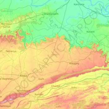
Name: Rewa topographic map, elevation, terrain.

Location: Rewa, Madhya Pradesh, India (24.31992 81.04636 25.19334 82.30619)

Average elevation: 252 m

Minimum elevation: 64 m

Maximum elevation: 712 m

Other topographic maps

Click on a map to view its topography, its elevation and its terrain.

Pachmarhi

India > Madhya Pradesh > Pipariya Tahsil

Average elevation: 968 m

Sonagiri

India > Madhya Pradesh > Badoni Tahsil

Average elevation: 216 m

Mod

India > Madhya Pradesh

Average elevation: 356 m

Plain Land

India > Madhya Pradesh > Shahdol District

Average elevation: 463 m

Dilauri

India > Madhya Pradesh > Raghurajnagar Tahsil

Average elevation: 327 m

Rew

India > Madhya Pradesh > Karera Tahsil

Average elevation: 246 m

Karatha

India > Madhya Pradesh > Nowgong Tahsil > Karatha

Average elevation: 213 m

Gear up for your next adventure:

🍳Camping Cookware - Cookware sets for outdoor meals
🧥Softshell Jackets - Flexible outdoor jackets
Lightweight Tents - Compact tents for backpacking
☀️Portable Solar Chargers - High-efficiency panels to hang on your backpack while walking
🧴Sunscreen SPF - Sun protection for outdoor activities

As an Amazon Associate, this site earns from qualifying purchases at no extra cost to you.