
Make a donation
Gear up for your next adventure:
As an Amazon Associate, this site earns from qualifying purchases at no extra cost to you.
Carro topographic map
Click on the map to display elevation.
Make a donation
Gear up for your next adventure:
As an Amazon Associate, this site earns from qualifying purchases at no extra cost to you.
About this map
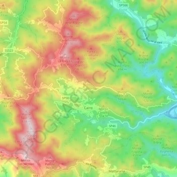
Name: Carro topographic map, elevation, terrain.
Location: Carro, La Spezia, Liguria, 19012, Italy (44.24997 9.56716 44.31114 9.66725)
Average elevation: 470 m
Minimum elevation: 167 m
Maximum elevation: 855 m
Make a donation
Gear up for your next adventure:
As an Amazon Associate, this site earns from qualifying purchases at no extra cost to you.
Other topographic maps
Click on a map to view its topography, its elevation and its terrain.
Make a donation
Gear up for your next adventure:
As an Amazon Associate, this site earns from qualifying purchases at no extra cost to you.
Make a donation
Gear up for your next adventure:
As an Amazon Associate, this site earns from qualifying purchases at no extra cost to you.
Make a donation
Gear up for your next adventure:
As an Amazon Associate, this site earns from qualifying purchases at no extra cost to you.
La Spezia
Because of its topography, the city is not exposed to winds from the north, which lap western Liguria, but to those from the southeast. These may bring heavy rain and they can reach 80 kilometres per hour (50 mph), in rare cases causing the blocking of the port. The only northern wind reaching the city is the…
Average elevation: 35 m
Make a donation
Gear up for your next adventure:
As an Amazon Associate, this site earns from qualifying purchases at no extra cost to you.