Geolocate

Kóspallag topographic map

Interactive map

Click on the map to display elevation.

About this map

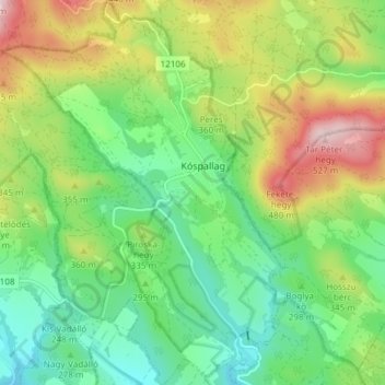
Name: Kóspallag topographic map, elevation, terrain.

Location: Kóspallag, Szobi járás, Pest, Central Hungary, 2625, Hungary (47.84538 18.89357 47.89565 18.95109)

Average elevation: 308 m

Minimum elevation: 183 m

Maximum elevation: 530 m

Other topographic maps

Click on a map to view its topography, its elevation and its terrain.

Mogyoród

Hungary > Pest

Mogyoród, Gödöllő Regional Unit, Pest, Central Hungary, 2146, Hungary

Average elevation: 203 m

Kartal

Hungary > Pest

Kartal, Aszódi járás, Pest, Central Hungary, 2173, Hungary

Average elevation: 167 m

Aszód

Hungary > Pest > Aszód

Aszód, Aszódi járás, Pest, Central Hungary, 2170, Hungary

Average elevation: 193 m

Csömör

Hungary > Pest > Csömör

Csömör, Gödöllő Regional Unit, Pest, Central Hungary, Hungary

Average elevation: 195 m

Érd

Hungary > Pest > Érd > Érd

Érd, Érdi járás, Pest, Central Hungary, 2030, Hungary

Average elevation: 133 m

Kismaros

Hungary > Pest > Kismaros

Kismaros, Szobi járás, Pest, Central Hungary, Hungary

Average elevation: 207 m