
Make a donation
Gear up for your next adventure:
As an Amazon Associate, this site earns from qualifying purchases at no extra cost to you.
Ticino topographic map
Click on the map to display elevation.
Make a donation
Gear up for your next adventure:
As an Amazon Associate, this site earns from qualifying purchases at no extra cost to you.
Ticino
Although it includes the lowest point of Switzerland (Lake Maggiore) as well as its lowest town (Ascona), the topography of Ticino is extremely rugged, as it is the fourth canton with the biggest elevation difference. It lies essentially within the Alps, in particular the Lepontine Alps, the Saint-Gotthard Massif and the Lugano Prealps. The longest and deepest valleys are those of the Ticino, Verzasca and Maggia. The two highest mountains are the Rheinwaldhorn and the Basòdino. Other notable mountains are Pizzo Rotondo (highest of the Gotthard Massif), Pizzo Campo Tencia (highest fully within the canton), Monte Generoso (highest south of Lake Lugano) and Monte Tamaro (most prominent of the canton). For an exhaustive list, see list of mountains of Ticino.
Make a donation
Gear up for your next adventure:
As an Amazon Associate, this site earns from qualifying purchases at no extra cost to you.
About this map
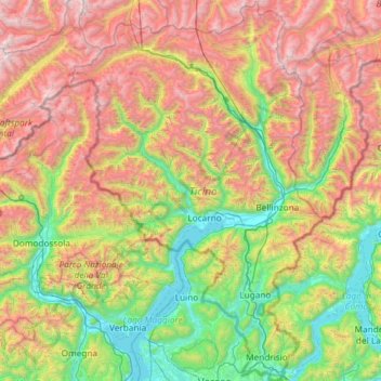
Name: Ticino topographic map, elevation, terrain.
Location: Ticino, Switzerland (45.81797 8.38204 46.63249 9.15970)
Average elevation: 1,389 m
Minimum elevation: 187 m
Maximum elevation: 3,546 m
Make a donation
Gear up for your next adventure:
As an Amazon Associate, this site earns from qualifying purchases at no extra cost to you.
Other topographic maps
Click on a map to view its topography, its elevation and its terrain.
Monte Rosa
Switzerland > Wallis > Visp > Zermatt
The peak is distinguished by the name Dufourspitze (in German, lit. Dufour Peak; French: Pointe Dufour, Italian: Punta Dufour). This replaced the former name Höchste Spitze (English: Highest Peak) that was indicated on the Swiss maps before the Federal Council, on January 28, 1863, decided to rename the…
Average elevation: 4,033 m
Make a donation
Gear up for your next adventure:
As an Amazon Associate, this site earns from qualifying purchases at no extra cost to you.
Kiental
Switzerland > Bern > Frutigen-Niedersimmental administrative district > Reichenbach im Kandertal
Average elevation: 1,363 m
Strandweg
Switzerland > St. Gallen > Wahlkreis See-Gaster > Rapperswil-Jona > Rapperswil
Average elevation: 408 m
Ramosch
Switzerland > Grisons > Region Engiadina Bassa/Val Müstair > Valsot
Average elevation: 1,501 m
Make a donation
Gear up for your next adventure:
As an Amazon Associate, this site earns from qualifying purchases at no extra cost to you.
Schloss Wittigkofen
Switzerland > Bern > Bern-Mittelland administrative district > Bern > Schloss Wittigkofen
Average elevation: 568 m
Make a donation
Gear up for your next adventure:
As an Amazon Associate, this site earns from qualifying purchases at no extra cost to you.
Bern
Switzerland > Bern > Bern-Mittelland administrative district > Bern
Bern is built on very uneven ground. An elevation difference of up to 60 metres exists between the inner city districts on the Aare (Matte, Marzili) and the higher ones (Kirchenfeld, Länggasse).
Average elevation: 643 m
Make a donation
Gear up for your next adventure:
As an Amazon Associate, this site earns from qualifying purchases at no extra cost to you.
Make a donation
Gear up for your next adventure:
As an Amazon Associate, this site earns from qualifying purchases at no extra cost to you.