Make a donation
Gear up for your next adventure:
As an Amazon Associate, this site earns from qualifying purchases at no extra cost to you.
Juneau County topographic map
Click on the map to display elevation.
Make a donation
Gear up for your next adventure:
As an Amazon Associate, this site earns from qualifying purchases at no extra cost to you.
About this map
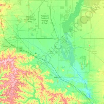
Name: Juneau County topographic map, elevation, terrain.
Location: Juneau County, Wisconsin, United States (43.64070 -90.31282 44.24971 -89.78526)
Average elevation: 302 m
Minimum elevation: 253 m
Maximum elevation: 441 m
Make a donation
Gear up for your next adventure:
As an Amazon Associate, this site earns from qualifying purchases at no extra cost to you.
Other topographic maps
Click on a map to view its topography, its elevation and its terrain.
Halls Creek
United States > Wisconsin > Florence County > Town of Commonwealth
Average elevation: 384 m
Make a donation
Gear up for your next adventure:
As an Amazon Associate, this site earns from qualifying purchases at no extra cost to you.
Make a donation
Gear up for your next adventure:
As an Amazon Associate, this site earns from qualifying purchases at no extra cost to you.
LaValle Mill Pond
United States > Wisconsin > Sauk County > Village of La Valle
Average elevation: 292 m
