
Cannon County topographic map
Interactive map
Click on the map to display elevation.
About this map
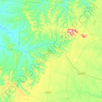
Name: Cannon County topographic map, elevation, terrain.
Location: Cannon County, Middle Tennessee, Tennessee, United States (35.64480 -86.21862 35.96692 -85.88026)
Average elevation: 300 m
Minimum elevation: 174 m
Maximum elevation: 634 m
Other topographic maps
Click on a map to view its topography, its elevation and its terrain.
Three Top Mountain;Threetop Mountain
United States > Tennessee > Cocke County
Average elevation: 766 m
Strawberry Plains Fortification
United States > Tennessee > Jefferson County > Strawberry Plains
Average elevation: 276 m
Tennessee River Pulp and Paper Company East Dam
United States > Tennessee > Hardin County
Average elevation: 129 m
Quail Run
United States > Tennessee > Rutherford County > Murfreesboro > Quail Run
Average elevation: 184 m
Clifton Hills
United States > Tennessee > Hamilton County > Chattanooga > Clifton Hills
Average elevation: 209 m