
Make a donation
Gear up for your next adventure:
As an Amazon Associate, this site earns from qualifying purchases at no extra cost to you.
Dyke topographic map
Click on the map to display elevation.
Make a donation
Gear up for your next adventure:
As an Amazon Associate, this site earns from qualifying purchases at no extra cost to you.
About this map
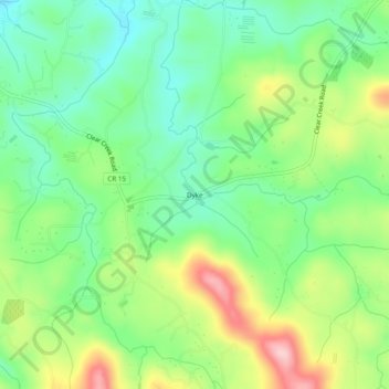
Name: Dyke topographic map, elevation, terrain.
Location: Dyke, Gilmer County, Georgia, 30636, United States (34.57981 -84.43159 34.61981 -84.39159)
Average elevation: 508 m
Minimum elevation: 435 m
Maximum elevation: 633 m
Make a donation
Gear up for your next adventure:
As an Amazon Associate, this site earns from qualifying purchases at no extra cost to you.
Other topographic maps
Click on a map to view its topography, its elevation and its terrain.
Ellijay
United States > Georgia > Gilmer County
Ellijay sits within a rugged and mountainous terrain, characterized by rolling hills, deep valleys, and ridgelines that are part of the larger Appalachian Mountain system. The area has an average elevation of about 1,390 feet, though nearby peaks like Walnut Mountain rise to elevations over 2,500 feet. The…
Average elevation: 424 m
Ellijay
United States > Georgia > Gilmer County
Ellijay lies within the Humid subtropical climate zone along with the majority of the rest of the Southeastern United States. The highest elevations in the surrounding region reside in the oceanic climate. Ellijay enjoys cool winters and warm summers, but neither would be considered extreme due to its slightly…
Average elevation: 424 m
Make a donation
Gear up for your next adventure:
As an Amazon Associate, this site earns from qualifying purchases at no extra cost to you.
Make a donation
Gear up for your next adventure:
As an Amazon Associate, this site earns from qualifying purchases at no extra cost to you.
Ellijay
United States > Georgia > Gilmer County
Ellijay lies within the Humid subtropical climate zone along with the majority of the rest of the southeastern United States. The highest elevations in the surrounding region reside in the Subtropical highland climate. Ellijay enjoys cool winters and warm summers, but neither would be considered extreme thanks…
Average elevation: 424 m