Geolocate
👉 Easily get elevation data in JSON, GeoTIFF and KML formats using Elevation API
Thank you for supporting this site ❤️
Make a donation

Geithus topographic map

Click on the map to display elevation.

About this map

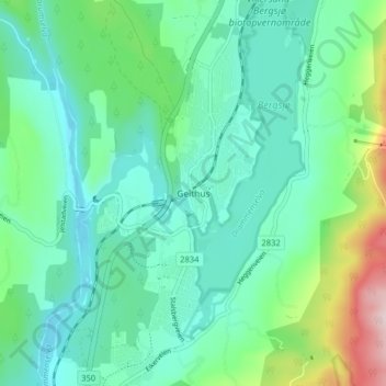
Name: Geithus topographic map, elevation, terrain.

Location: Geithus, Modum, Viken, 3360, Norway (59.91203 9.94793 59.95203 9.98793)

Average elevation: 106 m

Minimum elevation: 29 m

Maximum elevation: 370 m

Other topographic maps

Click on a map to view its topography, its elevation and its terrain.

Aremark

Norway > Viken

Average elevation: 150 m

Hemsedal

Norway > Viken

Average elevation: 1,217 m

Rollag

Norway > Viken

Average elevation: 652 m

Nordre Follo

Norway > Viken

Average elevation: 142 m

Fødalen landskapsvernområde

Norway > Viken

Average elevation: 1,483 m

Indre Østfold

Norway > Viken

Average elevation: 148 m

Moss

Norway > Viken

Average elevation: 23 m

Drammen

Norway > Viken

Average elevation: 209 m

Hvaler

Norway > Viken

Average elevation: 2 m

Nittedal

Norway > Viken

Average elevation: 296 m

Flå

Norway > Viken

Average elevation: 719 m

Gear up for your next adventure:

🔥Ferrocerium Rod Fire Starters - Reliable fire lighting in wet or windy conditions without matches
📣High-Decibel Survival Whistles - Signaling tool for rescue that carries much further than a human voice
🌬️Windbreaker Jackets - Wind protection jackets
🐍Snake Gaiters - Protection against snake bites
🧊Insulated Stainless Steel Flasks - Keep water cold for 24 hours in the heat or coffee hot in the cold

As an Amazon Associate, this site earns from qualifying purchases at no extra cost to you.