Geolocate

Hvaler topographic map

Click on the map to display elevation.

About this map

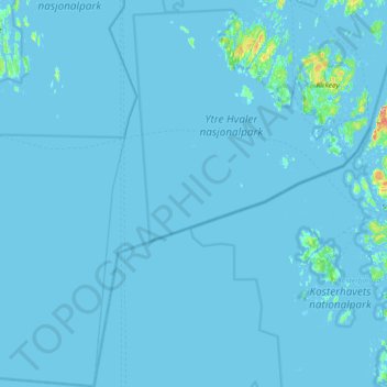
Name: Hvaler topographic map, elevation, terrain.

Location: Hvaler, Viken, Norway (58.76096 10.59310 59.13920 11.16734)

Average elevation: 2 m

Minimum elevation: -1 m

Maximum elevation: 110 m

Other topographic maps

Click on a map to view its topography, its elevation and its terrain.

Geilo

Norway > Viken

Average elevation: 871 m

Sokna

Norway > Viken

Average elevation: 182 m

Drammen

Norway > Viken

Average elevation: 219 m

Geithus

Norway > Viken

Average elevation: 106 m

Fødalen landskapsvernområde

Norway > Viken

Average elevation: 1,483 m

Krøderen

Norway > Viken > Krøderen

Average elevation: 208 m

Vinterbro

Norway > Viken > Vinterbro

Average elevation: 91 m

Krokhol

Norway > Viken

Average elevation: 193 m

Jessheim

Norway > Viken

Average elevation: 191 m

Krok

Norway > Viken > Mjøndalen

Average elevation: 70 m

Moss

Norway > Viken

Average elevation: 42 m

Høvik verk

Norway > Viken

Average elevation: 21 m

Gear up for your next adventure:

🔑Heavy Duty Carabiners - Secure gear to the outside of your pack for easy access
🧥Softshell Jackets - Flexible outdoor jackets
🗺️Topographic Maps - Detailed maps for hiking and navigation
📖Australian Bush Survival Books - Local knowledge on finding water and surviving the outback
🔥Windproof Plasma Lighters - USB rechargeable lighters that work in high-altitude winds

As an Amazon Associate, this site earns from qualifying purchases at no extra cost to you.