Geolocate

Drammen topographic map

Click on the map to display elevation.

About this map

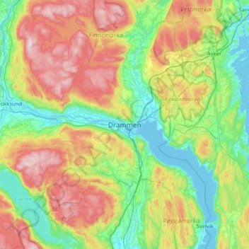
Name: Drammen topographic map, elevation, terrain.

Location: Drammen, Viken, 3017, Norway (59.58368 10.04436 59.90368 10.36436)

Average elevation: 219 m

Minimum elevation: -3 m

Maximum elevation: 646 m

Other topographic maps

Click on a map to view its topography, its elevation and its terrain.

Fødalen landskapsvernområde

Norway > Viken

Average elevation: 1,483 m

Nordre Follo

Norway > Viken

Average elevation: 142 m

Hemsedal

Norway > Viken

Average elevation: 1,217 m

Indre Østfold

Norway > Viken

Average elevation: 148 m

Aremark

Norway > Viken

Average elevation: 150 m

Rollag

Norway > Viken

Average elevation: 652 m

Moss

Norway > Viken

Average elevation: 23 m

Flå

Norway > Viken

Average elevation: 719 m

Drammen

Norway > Viken

Average elevation: 209 m

Hvaler

Norway > Viken

Average elevation: 2 m

Nittedal

Norway > Viken

Average elevation: 296 m

Gear up for your next adventure:

🔦LED Torches - LED torches for outdoor use
🗺️Topographic Maps - Detailed maps for hiking and navigation
📸Action Cameras - Record your journey across interesting topographic features in 4K
🔋Solar Power Banks - Charge your phone and GPS using the sun while deep in the bush
🍳Ultralight Camping Stoves - Boil water quickly for meals using minimal fuel

As an Amazon Associate, this site earns from qualifying purchases at no extra cost to you.