
Dinant topographic map
Interactive map
Click on the map to display elevation.
About this map
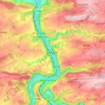
Name: Dinant topographic map, elevation, terrain.
Location: Dinant, Namen, Wallonië, 5500, België (50.21918 4.87306 50.29918 4.95306)
Average elevation: 204 m
Minimum elevation: 76 m
Maximum elevation: 294 m
De Kabelbaan van Dinant uit 1956, gerenoveerd in 1997, verbindt de binnenstad met de citadel en heeft een hoogteverschil van zo'n 150m.
Other topographic maps
Click on a map to view its topography, its elevation and its terrain.