
Lwamugolode topographic map
Interactive map
Click on the map to display elevation.
About this map
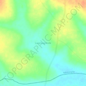
Name: Lwamugolode topographic map, elevation, terrain.
Location: Lwamugolode, Nakasongola, Central Region, Uganda (1.07083 32.70278 1.11083 32.74278)
Average elevation: 1,062 m
Minimum elevation: 1,045 m
Maximum elevation: 1,086 m
Other topographic maps
Click on a map to view its topography, its elevation and its terrain.
Kafu River
Uganda > Nakasongola > Kyajongo
Kafu River, Kyajongo, Nakasongola, Central Region, Uganda
Average elevation: 1,043 m
Kyambogo
Uganda > Nakasongola > Kyambogo
Kyambogo, Nakasongola, Central Region, Uganda
Average elevation: 1,080 m