
Dornelas topographic map
Interactive map
Click on the map to display elevation.
About this map
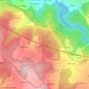
Name: Dornelas topographic map, elevation, terrain.
Location: Dornelas, Silleda, Deza, Pontevedra, Galicia, España (42.75003 -8.36260 42.77352 -8.32411)
Average elevation: 240 m
Minimum elevation: 69 m
Maximum elevation: 359 m
Other topographic maps
Click on a map to view its topography, its elevation and its terrain.
Pontenoufe
Pontenoufe, A Xesta, Lalín, Deza, Pontevedra, Galicia, 36515, España
Average elevation: 567 m