
O Castro topographic map
Interactive map
Click on the map to display elevation.
About this map
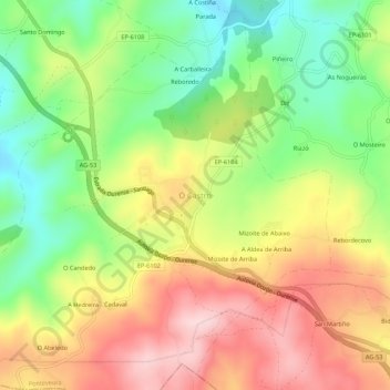
Name: O Castro topographic map, elevation, terrain.
Location: O Castro, Dozón, Deza, Pontevedra, Galicia, 36518, España (42.55219 -8.06659 42.59219 -8.02659)
Average elevation: 717 m
Minimum elevation: 580 m
Maximum elevation: 864 m
Other topographic maps
Click on a map to view its topography, its elevation and its terrain.
Pontenoufe
Pontenoufe, A Xesta, Lalín, Deza, Pontevedra, Galicia, 36515, España
Average elevation: 567 m