Geolocate

County Laois topographic map

Interactive map

Click on the map to display elevation.

About this map

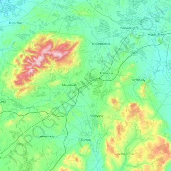
Name: County Laois topographic map, elevation, terrain.

Location: County Laois, Leinster, Ireland (52.78130 -7.73450 53.21562 -6.93190)

Average elevation: 132 m

Minimum elevation: 45 m

Maximum elevation: 524 m

Other topographic maps

Click on a map to view its topography, its elevation and its terrain.

Glackmore

Ireland > County Donegal

Average elevation: 223 m

Mangerton

Ireland > County Kerry

Mangerton Mountain's height and topographic prominence, qualifies it to meet the British Isles Marilyn classification, as well as the Arderin, Simm and Hewitt classifications. Mangerton Mountain ranks as the 10th-highest mountain in Ireland on the MountainViews Online Database, 100 Highest Irish Mountains,…

Average elevation: 657 m

Tearaght Island

Ireland > County Kerry

Average elevation: 1 m

Dunlewey Lough

Ireland > County Donegal

Average elevation: 169 m

Blanchardstown

Ireland > County Dublin

Blanchardstown was a predominantly rural area, with a small village, in western County Dublin, alongside the neighbouring district of Castleknock. Both areas shared a common history until well into the 19th century, when their development diverged. In A Topographical Dictionary of Ireland, published in 1837,…

Average elevation: 61 m

Ballyboden

Ireland > County Dublin

Average elevation: 83 m

Dún Laoghaire

Ireland > County Dublin

Average elevation: 21 m

Powderly Lower

Ireland > County Donegal > Kildoney

Average elevation: 57 m

Waterfall

Ireland > County Cork

Average elevation: 96 m

Cliffs of Moher

Ireland > County Clare

Average elevation: 55 m

Ongar

Ireland

Average elevation: 63 m

The Glen

Ireland > County Cork > Cork

Average elevation: 57 m

Connolly

Ireland > County Clare

Average elevation: 96 m

Dundrum

Ireland

Average elevation: 79 m

Glenbrook

Ireland > County Cork

Average elevation: 50 m

Mother Mountain

Ireland > County Tipperary

Average elevation: 368 m

Ruan

Ireland > County Clare

Average elevation: 22 m

Blessington

Ireland > County Wicklow

Average elevation: 205 m

Castleknock

Ireland > County Dublin

As the word Castle did not come into use in Ireland until Norman times we know that Castleknock is a name of comparatively recent origin. Documents from the 12th and 13th centuries refer to the place as Castrum Cnoc, simply Cnoc and also Chastel-cnoc or Castel-Cnoc.[8] So it seems that the name Castleknock is…

Average elevation: 55 m

Kilmacow

Ireland > County Kilkenny > Kilmacow

Average elevation: 28 m

Swords

Ireland > County Dublin > Swords

At the northern end of the street stands Swords Castle, 200m northeast of the ecclesiastical site, which was built in the early 13th century. A short distance north of the castle is the elevation known as Spittal Hill, where a hospital once stood.

Average elevation: 28 m

Liffey

Ireland > Dublin

Average elevation: 2 m

Robe

Ireland

Average elevation: 40 m

Mountain River

Ireland

Average elevation: 58 m

Curramore

Ireland

Average elevation: 119 m

Broadford

Ireland > County Clare

Average elevation: 95 m

Kilvine Electoral Division

Ireland > Irishtown

Average elevation: 69 m

Neale Electoral Division

Ireland > Neale

Average elevation: 35 m

Moyle

Ireland

Average elevation: 89 m

Gregory Hill

Ireland > Letterkenny

Average elevation: 216 m

Chapel Street

Ireland

Average elevation: 62 m

Wilton Castle

Ireland

Average elevation: 41 m

Philipstown

Ireland > Philipstown

Average elevation: 104 m

Knocknarea

Ireland

Average elevation: 104 m

Ashbourne

Ireland > County Meath > Ashbourne

Average elevation: 78 m

Cornelscourt

Ireland > County Dublin > Cornelscourt

Average elevation: 59 m

Carlingford

Ireland > County Louth > Carlingford

Average elevation: 84 m

Kinsale

Ireland > County Cork > Kinsale

Average elevation: 44 m

Tullamore

Ireland > County Offaly > Tullamore

Average elevation: 66 m

Donard

Ireland > County Wicklow > Donard

Average elevation: 218 m

Menlo

Ireland > County Galway > Menlo

Average elevation: 22 m