
Make a donation
Gear up for your next adventure:
As an Amazon Associate, this site earns from qualifying purchases at no extra cost to you.
Rincon topographic map
Click on the map to display elevation.
Make a donation
Gear up for your next adventure:
As an Amazon Associate, this site earns from qualifying purchases at no extra cost to you.
About this map
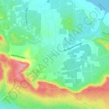
Name: Rincon topographic map, elevation, terrain.
Location: Rincon, Bonaire, Netherlands (12.21867 -68.34982 12.25867 -68.30982)
Average elevation: 40 m
Minimum elevation: 0 m
Maximum elevation: 119 m
Make a donation
Gear up for your next adventure:
As an Amazon Associate, this site earns from qualifying purchases at no extra cost to you.
Other topographic maps
Click on a map to view its topography, its elevation and its terrain.
Make a donation
Gear up for your next adventure:
As an Amazon Associate, this site earns from qualifying purchases at no extra cost to you.
Walcheren
Topographic map of Walcheren, 2015-2016. Click to enlarge.
Average elevation: 0 m
Make a donation
Gear up for your next adventure:
As an Amazon Associate, this site earns from qualifying purchases at no extra cost to you.
Bonaire
Klein Bonaire, the small island in the sheltered lee of Bonaire, has the same geological history. While Bonaire has some hills and variations in altitude, Klein Bonaire's surface is quite level and just a few feet above high tide. Because the island is as yet undeveloped, the fringing reef system surrounding…
Average elevation: 6 m
Make a donation
Gear up for your next adventure:
As an Amazon Associate, this site earns from qualifying purchases at no extra cost to you.
Noordoostpolder
Dutch topographic map of the municipality of Noordoostpolder, June 2015
Average elevation: -1 m
Make a donation
Gear up for your next adventure:
As an Amazon Associate, this site earns from qualifying purchases at no extra cost to you.
Make a donation
Gear up for your next adventure:
As an Amazon Associate, this site earns from qualifying purchases at no extra cost to you.
Make a donation
Gear up for your next adventure:
As an Amazon Associate, this site earns from qualifying purchases at no extra cost to you.
Make a donation
Gear up for your next adventure:
As an Amazon Associate, this site earns from qualifying purchases at no extra cost to you.
Make a donation
Gear up for your next adventure:
As an Amazon Associate, this site earns from qualifying purchases at no extra cost to you.
Vlissingen
Netherlands > Zeeland > Vlissingen
Topographic map of Vlissingen (city), Sept. 2014
Average elevation: 0 m
Make a donation
Gear up for your next adventure:
As an Amazon Associate, this site earns from qualifying purchases at no extra cost to you.
Make a donation
Gear up for your next adventure:
As an Amazon Associate, this site earns from qualifying purchases at no extra cost to you.
Purmerend
Netherlands > North Holland > Purmerend
Dutch Topographic map of Purmerend (town), as of March 2014.
Average elevation: -2 m
Make a donation
Gear up for your next adventure:
As an Amazon Associate, this site earns from qualifying purchases at no extra cost to you.
Make a donation
Gear up for your next adventure:
As an Amazon Associate, this site earns from qualifying purchases at no extra cost to you.
Make a donation
Gear up for your next adventure:
As an Amazon Associate, this site earns from qualifying purchases at no extra cost to you.