
Make a donation
Gear up for your next adventure:
As an Amazon Associate, this site earns from qualifying purchases at no extra cost to you.
Amhara Region topographic map
Click on the map to display elevation.
Make a donation
Gear up for your next adventure:
As an Amazon Associate, this site earns from qualifying purchases at no extra cost to you.
Amhara Region
The Amhara region has the most world heritage sites of any region in Ethiopia and is endowed with natural and geographic wonders and ecosystems. The region contains Ethiopia's largest inland body of water Lake Tana, which is the source of the Blue Nile river. In 2015 Lake Tana was recognized as a UNESCO Biosphere Reserve for its enormous biodiversity, and national and international importance. The Semien Mountains National Park has been designated as the one of the first natural World Heritage Site by UNESCO in the world, and the very first in Africa in the natural criteria since 1978. Chosen for its spectacular landscapes and global significance for biodiversity conservation. Situated within the Semien Mountains, Ethiopia's highest peaks Ras Dashen reaches an elevation of (4,543 m (14,905 ft)). The park also has Ethiopia's second and third highest mountains, Kidis Yared (4,453 m (14,610 ft)) and Mount Bwahit (4,437 m (14,557 ft)). The park is home to endangered species found nowhere else in the world, examples of endemic fauna include the iconic walia ibex, the gelada baboon, and the Ethiopian wolf (or Simien fox) among others. The wide range of altitudes has given the country a variety of ecologically distinct areas, leading to the evolution of endemic species in ecological isolation.
Make a donation
Gear up for your next adventure:
As an Amazon Associate, this site earns from qualifying purchases at no extra cost to you.
About this map
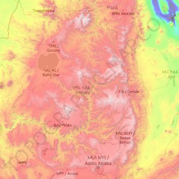
Name: Amhara Region topographic map, elevation, terrain.
Location: Amhara Region, Ethiopia (8.71589 35.26165 13.78090 40.21334)
Average elevation: 1,618 m
Minimum elevation: -114 m
Maximum elevation: 4,454 m
Make a donation
Gear up for your next adventure:
As an Amazon Associate, this site earns from qualifying purchases at no extra cost to you.
Other topographic maps
Click on a map to view its topography, its elevation and its terrain.
Addis Ababa
Ethiopia > Addis Ababa > Arada
Moreover, the city held strong social organization patterns prior to the Italian invasion. According to Richard Pankhurst (1968), the city's accelerated population growth was due to factors of provisional governors and their troops, the 1892 famine, and eventually the Battle of Adwa. Another includes the 1907…
Average elevation: 2,517 m
Make a donation
Gear up for your next adventure:
As an Amazon Associate, this site earns from qualifying purchases at no extra cost to you.
Jijiga
Ethiopia > Somali Region > Jijiga
Jijiga (Somali: Jigjiga, Amharic: ጅጅጋ, Jijiga) is the capital city of Somali Region, Ethiopia. It became the capital of the Somali Region in 1995 after it was moved from Gode. Located in the Fafan Zone with 70 km (37 mi) west of the border with Somalia, the city has an elevation of 1,934 metres above sea…
Average elevation: 1,732 m
Make a donation
Gear up for your next adventure:
As an Amazon Associate, this site earns from qualifying purchases at no extra cost to you.
Make a donation
Gear up for your next adventure:
As an Amazon Associate, this site earns from qualifying purchases at no extra cost to you.
Make a donation
Gear up for your next adventure:
As an Amazon Associate, this site earns from qualifying purchases at no extra cost to you.
Make a donation
Gear up for your next adventure:
As an Amazon Associate, this site earns from qualifying purchases at no extra cost to you.
Make a donation
Gear up for your next adventure:
As an Amazon Associate, this site earns from qualifying purchases at no extra cost to you.
Hayqoch And Butajira
Ethiopia > Southern Nations, Nationalities, and Peoples
Average elevation: 1,842 m
Make a donation
Gear up for your next adventure:
As an Amazon Associate, this site earns from qualifying purchases at no extra cost to you.