
Town of Monroe topographic map
Interactive map
Click on the map to display elevation.
About this map
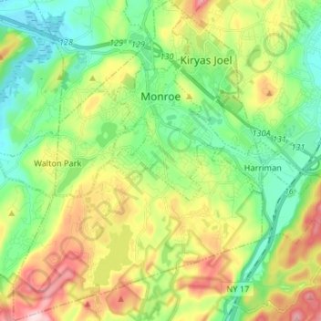
Name: Town of Monroe topographic map, elevation, terrain.
Location: Town of Monroe, Orange County, New York, United States (41.26109 -74.24752 41.36025 -74.14461)
Average elevation: 229 m
Minimum elevation: 126 m
Maximum elevation: 415 m
Other topographic maps
Click on a map to view its topography, its elevation and its terrain.
Cuddebackville
United States > New York > Orange County
Cuddebackville, Town of Deerpark, Orange County, New York, 12729, United States
Average elevation: 216 m
Village of Walden
United States > New York > Orange County
Village of Walden, Town of Montgomery, Orange County, New York, 12586, United States
Average elevation: 114 m
Hawks Nest
United States > New York > Orange County
Hawks Nest, Town of Deerpark, Orange County, New York, 18340, United States
Average elevation: 230 m
Village of Monroe
United States > New York > Orange County
Village of Monroe, Town of Monroe, Orange County, New York, 10950, United States
Average elevation: 217 m
Village of Tuxedo Park
United States > New York > Orange County > Town of Tuxedo
Village of Tuxedo Park, Town of Tuxedo, Orange County, New York, 10987, United States
Average elevation: 230 m