
Village of Monroe topographic map
Interactive map
Click on the map to display elevation.
About this map
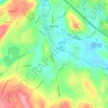
Name: Village of Monroe topographic map, elevation, terrain.
Average elevation: 217 m
Minimum elevation: 167 m
Maximum elevation: 294 m
Other topographic maps
Click on a map to view its topography, its elevation and its terrain.
Cuddebackville
United States > New York > Orange County
Cuddebackville, Town of Deerpark, Orange County, New York, 12729, United States
Average elevation: 216 m
Town of Monroe
United States > New York > Orange County
Town of Monroe, Orange County, New York, United States
Average elevation: 229 m
Village of Walden
United States > New York > Orange County
Village of Walden, Town of Montgomery, Orange County, New York, 12586, United States
Average elevation: 114 m
Hawks Nest
United States > New York > Orange County
Hawks Nest, Town of Deerpark, Orange County, New York, 18340, United States
Average elevation: 230 m
Village of Tuxedo Park
United States > New York > Orange County > Town of Tuxedo
Village of Tuxedo Park, Town of Tuxedo, Orange County, New York, 10987, United States
Average elevation: 230 m