
Gannett Peak topographic map
Interactive map
Click on the map to display elevation.
About this map
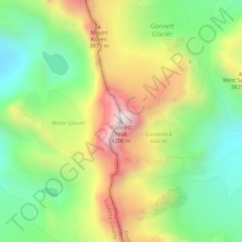
Name: Gannett Peak topographic map, elevation, terrain.
Location: Gannett Peak, Fremont County, Wyoming, VS (43.18435 -109.65409 43.18445 -109.65399)
Average elevation: 3,700 m
Minimum elevation: 3,335 m
Maximum elevation: 4,208 m
Other topographic maps
Click on a map to view its topography, its elevation and its terrain.
Yellowstone National Park
Yellowstone National Park, Mary Mountain-Nez Perce, Teton County, Wyoming, VS
Average elevation: 2,450 m
Rock Springs
VS > Wyoming > Rock Springs
Rock Springs, Sweetwater County, Wyoming, 82901, VS
Average elevation: 2,011 m
Grand Teton National Park
Grand Teton National Park, Teton Park Road, Teton County, Wyoming, 83013, VS
Average elevation: 2,409 m