
Union County topographic map
Interactive map
Click on the map to display elevation.
About this map
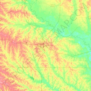
Name: Union County topographic map, elevation, terrain.
Location: Union County, Arkansas, VS (33.00802 -92.98870 33.38788 -92.06900)
Average elevation: 53 m
Minimum elevation: 14 m
Maximum elevation: 118 m
Other topographic maps
Click on a map to view its topography, its elevation and its terrain.
Ozark Plateau
Ozark Plateau, Coburn Loop, Clark County, Arkansas, VS
Average elevation: 51 m
Springdale
VS > Arkansas > Springdale
Springdale, Washington County, Arkansas, VS
Average elevation: 398 m