
Garland County topographic map
Interactive map
Click on the map to display elevation.
About this map
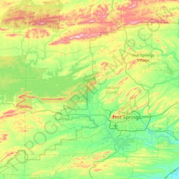
Name: Garland County topographic map, elevation, terrain.
Location: Garland County, Arkansas, VS (34.38916 -93.40769 34.77353 -92.79146)
Average elevation: 224 m
Minimum elevation: 68 m
Maximum elevation: 587 m
Other topographic maps
Click on a map to view its topography, its elevation and its terrain.
Ozark Plateau
Ozark Plateau, Coburn Loop, Clark County, Arkansas, VS
Average elevation: 51 m
Springdale
VS > Arkansas > Springdale
Springdale, Washington County, Arkansas, VS
Average elevation: 398 m