
Town of Berne topographic map
Interactive map
Click on the map to display elevation.
About this map
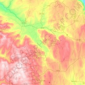
Name: Town of Berne topographic map, elevation, terrain.
Location: Town of Berne, Albany County, New York, United States (42.53780 -74.23942 42.65229 -74.00106)
Average elevation: 439 m
Minimum elevation: 112 m
Maximum elevation: 657 m
Other topographic maps
Click on a map to view its topography, its elevation and its terrain.
Horton Falls
United States > New York > Albany County > Town of New Scotland
Horton Falls, Town of New Scotland, Albany County, New York, 12159, United States
Average elevation: 88 m
Town of Guilderland
United States > New York > Albany County
Town of Guilderland, Albany County, New York, United States
Average elevation: 126 m
City of Cohoes
United States > New York > Albany County > City of Cohoes
City of Cohoes, Albany County, New York, 12047, United States
Average elevation: 39 m
Albany
United States > New York > Albany County > Albany
Albany, Albany County, New York, 12207, United States
Average elevation: 114 m
City of Albany
United States > New York > Albany County
City of Albany, Albany County, New York, United States
Average elevation: 68 m