
Gum Creek Station topographic map
Interactive map
Click on the map to display elevation.
About this map
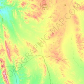
Name: Gum Creek Station topographic map, elevation, terrain.
Average elevation: 529 m
Minimum elevation: 276 m
Maximum elevation: 844 m
Pastoral Unincorporated Area trails, hiking, mountain biking, running and outdoor activities
Other topographic maps
Click on a map to view its topography, its elevation and its terrain.
Stokes Hill Lookout
Australia > South Australia > Pastoral Unincorporated Area
Average elevation: 684 m
Dullingari
Australia > South Australia > Pastoral Unincorporated Area > Innamincka
Average elevation: 89 m
Bookabourdie Waterhole
Australia > South Australia > Pastoral Unincorporated Area > Innamincka
Average elevation: 44 m
Fowlers Bay
Australia > South Australia > Pastoral Unincorporated Area > Fowlers Bay
Average elevation: 3 m
Mungerannie
Australia > South Australia > Pastoral Unincorporated Area > Mungerannie
Average elevation: 59 m
Moomba Gas and Oil Field
Australia > South Australia > Pastoral Unincorporated Area > Moomba Gas and Oil Field
Average elevation: 36 m
Leigh Creek
Australia > South Australia > Pastoral Unincorporated Area > Leigh Creek
Average elevation: 267 m
Lyndhurst
Australia > South Australia > Pastoral Unincorporated Area > Lyndhurst
Average elevation: 133 m