
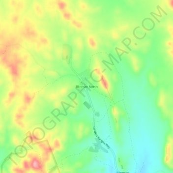
Blinman North topographic map
Interactive map
Click on the map to display elevation.
About this map
Name: Blinman North topographic map, elevation, terrain.
Average elevation: 628 m
Minimum elevation: 572 m
Maximum elevation: 702 m
Other topographic maps
Click on a map to view its topography, its elevation and its terrain.
Flinders Ranges
Australia > South Australia > Pastoral Unincorporated Area
Flinders Ranges, Pastoral Unincorporated Area, South Australia, Australia
Average elevation: 808 m
Hawker Hill
Australia > South Australia > Pastoral Unincorporated Area
Hawker Hill, Pastoral Unincorporated Area, South Australia, Australia
Average elevation: 593 m
Weekeroo
Australia > South Australia > Pastoral Unincorporated Area
Weekeroo, Pastoral Unincorporated Area, South Australia, 5440, Australia
Average elevation: 351 m
Marree
Australia > South Australia > Pastoral Unincorporated Area
Marree, Pastoral Unincorporated Area, South Australia, 5733, Australia
Average elevation: 46 m
Arcoona
Australia > South Australia > Pastoral Unincorporated Area
Arcoona, Pastoral Unincorporated Area, South Australia, 5720, Australia
Average elevation: 125 m
Paney Hill
Australia > South Australia > Pastoral Unincorporated Area
Paney Hill, Pastoral Unincorporated Area, South Australia, Australia
Average elevation: 374 m
Mern Merna
Australia > South Australia > Pastoral Unincorporated Area
Mern Merna, Flinders Ranges, Pastoral Unincorporated Area, South Australia, 5434, Australia
Average elevation: 267 m
McDouall Peak
Australia > South Australia > Pastoral Unincorporated Area
McDouall Peak, Pastoral Unincorporated Area, South Australia, 5723, Australia
Average elevation: 166 m
Mulgathing
Australia > South Australia > Pastoral Unincorporated Area
Mulgathing, Pastoral Unincorporated Area, South Australia, 5719, Australia
Average elevation: 161 m
Wilpena Pound
Australia > South Australia > Pastoral Unincorporated Area > Wilpena Pound
Wilpena Pound, Flinders Ranges, Pastoral Unincorporated Area, South Australia, 5434, Australia
Average elevation: 593 m
Fowlers Bay
Australia > South Australia > Pastoral Unincorporated Area
Fowlers Bay, Pastoral Unincorporated Area, South Australia, 5690, Australia
Average elevation: 28 m
Innamincka
Australia > South Australia > Pastoral Unincorporated Area
Innamincka, Pastoral Unincorporated Area, South Australia, 5731, Australia
Average elevation: 71 m
Bollards Lagoon
Australia > South Australia > Pastoral Unincorporated Area
Bollards Lagoon, Pastoral Unincorporated Area, South Australia, 5731, Australia
Average elevation: 70 m
Tarcoola
Australia > South Australia > Pastoral Unincorporated Area
Tarcoola, Pastoral Unincorporated Area, South Australia, 5701, Australia
Average elevation: 128 m
Marla
Australia > South Australia > Pastoral Unincorporated Area
Marla, Pastoral Unincorporated Area, South Australia, 5724, Australia
Average elevation: 325 m
Ooldea
Australia > South Australia > Pastoral Unincorporated Area
Ooldea, Pastoral Unincorporated Area, South Australia, Australia
Average elevation: 116 m
Wintinna
Australia > South Australia > Pastoral Unincorporated Area
Wintinna, Pastoral Unincorporated Area, South Australia, 5723, Australia
Average elevation: 273 m
Lake Hart
Australia > South Australia > Pastoral Unincorporated Area
Lake Hart, Pastoral Unincorporated Area, South Australia, Australia
Average elevation: 115 m
Gum Creek Station
Australia > South Australia > Pastoral Unincorporated Area
Gum Creek Station, Pastoral Unincorporated Area, South Australia, 5730, Australia
Average elevation: 529 m
Pimba
Australia > South Australia > Pastoral Unincorporated Area
Pimba, Pastoral Unincorporated Area, South Australia, 5720, Australia
Average elevation: 188 m
Puttapa
Australia > South Australia > Pastoral Unincorporated Area
Puttapa, Pastoral Unincorporated Area, South Australia, 5730, Australia
Average elevation: 321 m
Olympic Dam
Australia > South Australia > Pastoral Unincorporated Area
Olympic Dam, Pastoral Unincorporated Area, South Australia, 5725, Australia
Average elevation: 104 m
One Tree Hill
Australia > South Australia > Pastoral Unincorporated Area
One Tree Hill, Pastoral Unincorporated Area, South Australia, Australia
Average elevation: 351 m
Ikara-Flinders Ranges National Park
Australia > South Australia > Pastoral Unincorporated Area
Ikara-Flinders Ranges National Park, Pastoral Unincorporated Area, South Australia, Australia
Average elevation: 430 m
Mount Serle
Australia > South Australia > Pastoral Unincorporated Area
Mount Serle, Pastoral Unincorporated Area, South Australia, 5732, Australia
Average elevation: 423 m
Ironstone Hill Conservation Park
Australia > South Australia > Pastoral Unincorporated Area
Ironstone Hill Conservation Park, The District Council of Franklin Harbour, Pastoral Unincorporated Area, South Australia, Australia
Average elevation: 196 m
Yunta
Australia > South Australia > Pastoral Unincorporated Area
Yunta, Pastoral Unincorporated Area, South Australia, 5440, Australia
Average elevation: 347 m
Far West Coast Marine Park
Australia > South Australia > Pastoral Unincorporated Area
Far West Coast Marine Park, Pastoral Unincorporated Area, South Australia, Australia
Average elevation: 66 m
Leigh Creek
Australia > South Australia > Pastoral Unincorporated Area
Leigh Creek, Pastoral Unincorporated Area, South Australia, 5731, Australia
Average elevation: 278 m
Lake Acraman
Australia > South Australia > Pastoral Unincorporated Area
Lake Acraman, Pastoral Unincorporated Area, South Australia, Australia
Average elevation: 147 m
Nilpena
Australia > South Australia > Pastoral Unincorporated Area
Nilpena, Pastoral Unincorporated Area, South Australia, 5730, Australia
Average elevation: 107 m
Warraweena
Australia > South Australia > Pastoral Unincorporated Area
Warraweena, Pastoral Unincorporated Area, South Australia, 5730, Australia
Average elevation: 588 m
Nullarbor
Australia > South Australia > Pastoral Unincorporated Area
Nullarbor, Pastoral Unincorporated Area, South Australia, 5690, Australia
Average elevation: 88 m
Burr Well
Australia > South Australia > Pastoral Unincorporated Area
Burr Well, Pastoral Unincorporated Area, South Australia, 5732, Australia
Average elevation: 394 m
Manners Well
Australia > South Australia > Pastoral Unincorporated Area
Manners Well, Pastoral Unincorporated Area, South Australia, 5732, Australia
Average elevation: 552 m
Dare Hill
Australia > South Australia > Pastoral Unincorporated Area
Dare Hill, Pastoral Unincorporated Area, South Australia, Australia
Average elevation: 345 m
Mount Goddard
Australia > South Australia > Pastoral Unincorporated Area
Mount Goddard, Pastoral Unincorporated Area, South Australia, Australia
Average elevation: 548 m
Carrapateena Hill
Australia > South Australia > Pastoral Unincorporated Area
Carrapateena Hill, Pastoral Unincorporated Area, South Australia, Australia
Average elevation: 150 m
Olary
Australia > South Australia > Pastoral Unincorporated Area > Olary
Olary, Pastoral Unincorporated Area, South Australia, 5440, Australia
Average elevation: 283 m
Fowlers Bay
Australia > South Australia > Pastoral Unincorporated Area > Fowlers Bay
Fowlers Bay, Pastoral Unincorporated Area, South Australia, Australia
Average elevation: 3 m
Pernatty
Australia > South Australia > Pastoral Unincorporated Area
Pernatty, Pastoral Unincorporated Area, South Australia, 5713, Australia
Average elevation: 102 m
Mungerannie
Australia > South Australia > Pastoral Unincorporated Area > Mungerannie
Mungerannie, Mungeranie, Pastoral Unincorporated Area, South Australia, 5733, Australia
Average elevation: 59 m
Leigh Creek
Australia > South Australia > Pastoral Unincorporated Area > Leigh Creek
Leigh Creek, Pastoral Unincorporated Area, South Australia, Australia
Average elevation: 267 m
Lyndhurst
Australia > South Australia > Pastoral Unincorporated Area > Lyndhurst
Lyndhurst, Pastoral Unincorporated Area, South Australia, Australia
Average elevation: 133 m
Blinman
Australia > South Australia > Pastoral Unincorporated Area
Blinman, Pastoral Unincorporated Area, South Australia, 5730, Australia
Average elevation: 588 m
Arkaroola Village
Australia > South Australia > Pastoral Unincorporated Area
Arkaroola Village, Pastoral Unincorporated Area, South Australia, 5701, Australia
Average elevation: 392 m
Cultana
Australia > South Australia > Pastoral Unincorporated Area
Cultana, Pastoral Unincorporated Area, South Australia, 5700, Australia
Average elevation: 89 m
Gammon Ranges
Australia > South Australia > Pastoral Unincorporated Area
Gammon Ranges, Pastoral Unincorporated Area, South Australia, 5732, Australia
Average elevation: 325 m
Bookabie
Australia > South Australia > Pastoral Unincorporated Area
Bookabie, Pastoral Unincorporated Area, South Australia, 5690, Australia
Average elevation: 32 m
Oodnadatta
Australia > South Australia > Pastoral Unincorporated Area
Oodnadatta, Pastoral Unincorporated Area, South Australia, 5734, Australia
Average elevation: 130 m