
Lake McDonald topographic map
Interactive map
Click on the map to display elevation.
About this map
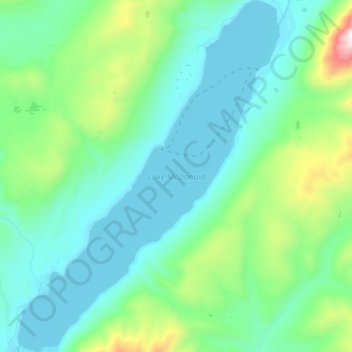
Name: Lake McDonald topographic map, elevation, terrain.
Location: Lake McDonald, Flathead County, Montana, United States (48.52745 -113.99626 48.64055 -113.86895)
Average elevation: 1,209 m
Minimum elevation: 954 m
Maximum elevation: 2,265 m
Lake McDonald is the largest lake in Glacier National Park. It is located at 48°35′N 113°55′W / 48.583°N 113.917°W / 48.583; -113.917 in Flathead County in the U.S. state of Montana. Lake McDonald is approximately 10 miles (16 km) long, and over a mile (1.6 km) wide and 472 feet (130 m) deep, filling a valley formed by a combination of erosion and glacial activity. Lake McDonald lies at an elevation of 3,153 feet (961 m) and is on the west side of the Continental Divide. Going-to-the-Sun Road parallels the lake along its southern shoreline. The surface area of the lake is 6,823 acres (27.6 km2).
Other topographic maps
Click on a map to view its topography, its elevation and its terrain.
Tunnel Creek
United States > Montana > Flathead County
Tunnel Creek, Flathead County, Montana, United States
Average elevation: 1,211 m
Kalispell
United States > Montana > Flathead County
Kalispell, Flathead County, Montana, United States
Average elevation: 934 m
West Glacier
United States > Montana > Flathead County > West Glacier
West Glacier, Flathead County, Montana, 59936, United States
Average elevation: 1,201 m