
Make a donation
Gear up for your next adventure:
As an Amazon Associate, this site earns from qualifying purchases at no extra cost to you.
Montgomery topographic map
Click on the map to display elevation.
Make a donation
Gear up for your next adventure:
As an Amazon Associate, this site earns from qualifying purchases at no extra cost to you.
Montgomery
Montgomery is located at 32°21′42″N 86°16′45″W / 32.36167°N 86.27917°W / 32.36167; -86.27917. According to the U.S. Census Bureau, the city has a total area of 156.2 square miles (405 km2), of which 155.4 square miles (402 km2) is land and 0.8 square miles (2.1 km2) (0.52%) is water. The city is built over rolling terrain at an elevation of about 220 feet (67 m) above sea level.
Make a donation
Gear up for your next adventure:
As an Amazon Associate, this site earns from qualifying purchases at no extra cost to you.
About this map
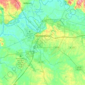
Name: Montgomery topographic map, elevation, terrain.
Location: Montgomery, Montgomery County, Alabama, United States (32.25055 -86.44301 32.43787 -86.06917)
Average elevation: 66 m
Minimum elevation: 37 m
Maximum elevation: 168 m
Make a donation
Gear up for your next adventure:
As an Amazon Associate, this site earns from qualifying purchases at no extra cost to you.
Other topographic maps
Click on a map to view its topography, its elevation and its terrain.
Woodmere Park
United States > Alabama > Montgomery County > Montgomery > Bellwood Plantation
Average elevation: 84 m
Make a donation
Gear up for your next adventure:
As an Amazon Associate, this site earns from qualifying purchases at no extra cost to you.
Greater Washington Park
United States > Alabama > Montgomery County > Montgomery
Average elevation: 53 m
Make a donation
Gear up for your next adventure:
As an Amazon Associate, this site earns from qualifying purchases at no extra cost to you.
Mountain View Estates
United States > Alabama > Montgomery County > Montgomery
Average elevation: 80 m
Make a donation
Gear up for your next adventure:
As an Amazon Associate, this site earns from qualifying purchases at no extra cost to you.
Make a donation
Gear up for your next adventure:
As an Amazon Associate, this site earns from qualifying purchases at no extra cost to you.
Regency Forest
United States > Alabama > Montgomery County > Montgomery > Regency Forest
Average elevation: 67 m
Bellwood Plantation
United States > Alabama > Montgomery County > Montgomery > Bellwood Plantation
Average elevation: 81 m