Geolocate

Monongahela National Forest topographic map

Interactive map

Click on the map to display elevation.

Monongahela National Forest

In 1943 and 1944, as part of the West Virginia Maneuver Area, the U.S. Army used parts of the Monongahela National Forest as a practice artillery and mortar range and maneuver area before troops were sent to Europe to fight in World War II. Artillery and mortar shells shot into the area for practice are still occasionally found there today. Seneca Rocks and other area cliffs were also used for assault climbing instruction. This was the Army's only low-altitude climbing school.

Wikipedia (CC-BY-SA 3.0)

About this map

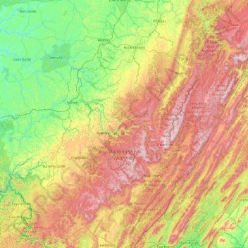
Name: Monongahela National Forest topographic map, elevation, terrain.

Location: Monongahela National Forest, West Virginia, United States (37.78304 -80.63264 39.27579 -77.92521)

Average elevation: 576 m

Minimum elevation: 170 m

Maximum elevation: 1,463 m

Other topographic maps

Click on a map to view its topography, its elevation and its terrain.

Engle

United States > West Virginia > Jefferson County

Average elevation: 133 m

Raleigh

United States > West Virginia > Raleigh County

Average elevation: 715 m

Lillydale

United States > West Virginia > Wyoming County

Average elevation: 493 m

Tad

United States > West Virginia > Kanawha County

Average elevation: 303 m

Atwell

United States > West Virginia > McDowell County

Average elevation: 559 m

Decota

United States > West Virginia > Kanawha County

Average elevation: 547 m

Lawn

United States > West Virginia > Greenbrier County

Average elevation: 792 m

Swann

United States > West Virginia > Cabell County

Average elevation: 242 m

Hewett

United States > West Virginia > Boone County

Average elevation: 382 m

Faraday

United States > West Virginia > McDowell County

Average elevation: 639 m

Green Bank Telescope

United States > West Virginia > Pocahontas County

As an azimuth-elevation mounting telescope, the azimuth adjustments are driven by four trucks with four wheels each on a 210-foot (64 m) diameter rail. The 16 thirty-horsepower motors can change azimuth at the rate of up to 40 degrees per minute. Azimuth axis is also supported by a pintle bearing at the center…

Average elevation: 822 m

Lego

United States > West Virginia > Raleigh County > Lego

Average elevation: 700 m

Mozart

United States > West Virginia > Ohio County > Wheeling > Mozart

Average elevation: 296 m

Location

United States > West Virginia > Tucker County

Average elevation: 722 m

Bradshaw

United States > West Virginia > Logan County

Average elevation: 393 m

Harlin

United States > West Virginia > Doddridge County > Harlin

Average elevation: 336 m

Core

United States > West Virginia > Core

Average elevation: 369 m

Cyclone

United States > West Virginia > Cyclone

Average elevation: 521 m

Kitsonville

United States > West Virginia > Weston > Kitsonville

Average elevation: 362 m

York

United States > West Virginia > Mason County > York

Average elevation: 189 m

English

United States > West Virginia > McDowell County > English

Average elevation: 558 m

Bula

United States > West Virginia > Monongalia County > Bula

Average elevation: 360 m