Geolocate

Pulaski topographic map

Click on the map to display elevation.

About this map
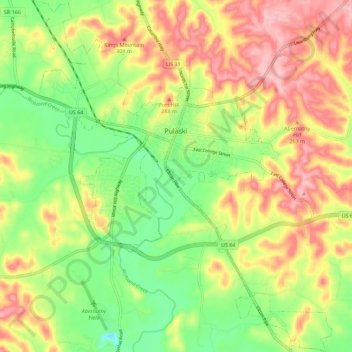
Name: Pulaski topographic map, elevation, terrain.

Location: Pulaski, Giles County, Middle Tennessee, Tennessee, 38478, United States (35.14181 -87.07699 35.23399 -86.98075)

Average elevation: 233 m

Minimum elevation: 158 m

Maximum elevation: 315 m

Other topographic maps

Click on a map to view its topography, its elevation and its terrain.

Rebel Acres

United States > Tennessee > Giles County > Pulaski

Average elevation: 242 m

Frankewing

United States > Tennessee > Giles County

Average elevation: 239 m

Prospect

United States > Tennessee > Giles County

Average elevation: 212 m

Goodspring

United States > Tennessee > Giles County

Average elevation: 280 m

Bufords

United States > Tennessee > Giles County

Average elevation: 235 m

Wales

United States > Tennessee > Giles County

Average elevation: 224 m

Gear up for your next adventure:

🧊Insulated Cooler Bags - Keep food fresh for day trips to remote geographic sites
📱Shockproof Phone Cases - Extra protection for your smartphone against drops on rocky terrain
🔭Compact Hiking Binoculars - Lightweight optics for scouting routes or birdwatching
🔥Ferrocerium Rod Fire Starters - Reliable fire lighting in wet or windy conditions without matches
🧼Biodegradable Outdoor Soap - Clean gear and yourself without harming the local ecosystem

As an Amazon Associate, this site earns from qualifying purchases at no extra cost to you.