Geolocate

Seale topographic map

Click on the map to display elevation.

About this map
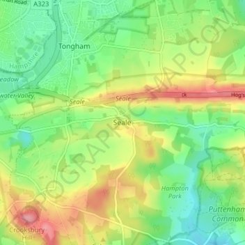
Name: Seale topographic map, elevation, terrain.

Location: Seale, Guildford, Surrey, England, GU10 1JZ, United Kingdom (51.20235 -0.73874 51.24235 -0.69874)

Average elevation: 94 m

Minimum elevation: 52 m

Maximum elevation: 155 m

Other topographic maps

Click on a map to view its topography, its elevation and its terrain.

Shalford

United Kingdom > England > Surrey > Guildford > Guildford

Lt.Col. Henry Haversham Godwin-Austen (1834–1923), topographer, geologist, naturalist and explorer who surveyed the Himalayan region, including K2, sometimes known as Mt. Godwin-Austen, for a time had an estate in Shalford.

Average elevation: 54 m
East Clandon

United Kingdom > England > Surrey > Guildford > West Clandon

Average elevation: 93 m

Shere

United Kingdom > England > Surrey > Guildford

Average elevation: 136 m

Send

United Kingdom > England > Surrey > Guildford > Send

Average elevation: 32 m

West Clandon

United Kingdom > England > Surrey > Guildford > West Clandon

Average elevation: 69 m

East Horsley

United Kingdom > England > Surrey > Guildford > East Horsley

Average elevation: 89 m

Pirbright

United Kingdom > England > Surrey > Guildford > Pirbright

Average elevation: 66 m

Tongham

United Kingdom > England > Surrey > Guildford > Tongham

Average elevation: 89 m

Compton

United Kingdom > England > Surrey > Guildford

Average elevation: 89 m

Effingham

United Kingdom > England > Surrey > Guildford

Average elevation: 105 m

Normandy

United Kingdom > England > Surrey > Guildford

Average elevation: 68 m

Ripley

United Kingdom > England > Surrey > Guildford

Average elevation: 35 m

Artington

United Kingdom > England > Surrey > Guildford > Guildford

Average elevation: 50 m

Puttenham

United Kingdom > England > Surrey > Guildford > Puttenham

Average elevation: 84 m

Farley Heath

United Kingdom > England > Surrey > Guildford

Average elevation: 105 m

Wanborough

United Kingdom > England > Surrey > Guildford > Wanborough

Average elevation: 91 m

Shere

United Kingdom > England > Surrey > Guildford

Average elevation: 136 m

Gear up for your next adventure:

🧥Packable Rain Jackets - Breathable waterproof layers for unpredictable mountain weather
🚁Camera Drones with GPS - Capture aerial views of the landscape to compare with topo maps
🔦Headlamps - Hands-free lighting for hiking
🔦Powerful LED Headlamps - Hands-free lighting for night navigation and setting up camp after dark
💧Personal Water Filters - Drink safely from streams and lakes identified on your map

As an Amazon Associate, this site earns from qualifying purchases at no extra cost to you.