
Trussville topographic map
Interactive map
Click on the map to display elevation.
About this map
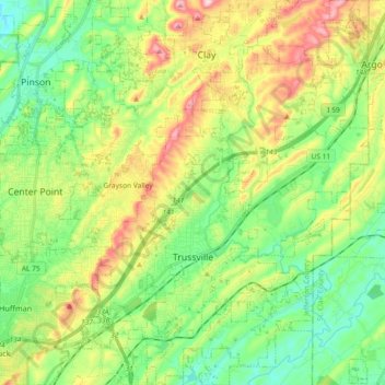
Name: Trussville topographic map, elevation, terrain.
Location: Trussville, Jefferson County, Alabama, 35173, United States (33.56892 -86.65220 33.72140 -86.50738)
Average elevation: 255 m
Minimum elevation: 156 m
Maximum elevation: 432 m
Other topographic maps
Click on a map to view its topography, its elevation and its terrain.
Birmingham
United States > Alabama > Jefferson County
Birmingham, Jefferson County, Alabama, United States
Average elevation: 193 m
Mount Olive
United States > Alabama > Jefferson County
Mount Olive, Jefferson County, Alabama, United States
Average elevation: 165 m
Valley Creek
United States > Alabama > Jefferson County > Birmingham > Graymont
Valley Creek, Smithfield Historic District, Graymont, Birmingham, Jefferson County, Alabama, 35204, United States
Average elevation: 181 m
Windsor Highlands
United States > Alabama > Jefferson County > Homewood > Windsor Highlands
Windsor Highlands, Homewood, Jefferson County, Alabama, 35209, United States
Average elevation: 240 m
Maytown
United States > Alabama > Jefferson County > Maytown
Maytown, Jefferson County, Alabama, United States
Average elevation: 178 m