
Tver Oblast topographic map
Interactive map
Click on the map to display elevation.
Tver Oblast
Tver Oblast as a whole is characterized by flat terrain with alternating lowlands and highlands due to its location in the East European Plain. In the western part of the province, occupying about one-third of its area is Valdai Hills, with elevations of 200–300 m above sea level. It is surrounded by depressions, lowlands have a height of 100–150 m highest point of the area has a height of 347 m, is located on a hill Tsninsky (The top of the Valdai). The low point (61 m) - the extreme north-west area of the river's edge Kunya (Russian: Кунья) on the border with the Novgorod Oblast.
About this map
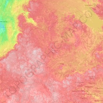
Name: Tver Oblast topographic map, elevation, terrain.
Location: Tver Oblast, Central Federal District, Russia (55.63203 30.72839 58.86314 38.32686)
Average elevation: 164 m
Minimum elevation: 15 m
Maximum elevation: 341 m
Other topographic maps
Click on a map to view its topography, its elevation and its terrain.
Sadon
Russia > Republic of North Ossetia – Alania > Alagirsky District > Sadon
Average elevation: 2,161 m
Batagaika crater
Russia > Sakha Republic > Verkhoyansky Ulus
According to a conference paper published in 2016 the crater did not show any signs of stabilization after several decades (since 1980s) of slump growth, with the headwall retreating with observed rates of generally >10 m and up to 30m per year closer to 2016. Reconstruction of a paleo-surface revealed that…
Average elevation: 263 m
The Goat Cape
Russia > Krasnoyarsk Krai > Krasnoyarsk Urban Okrug > Krasnoyarsk
Average elevation: 271 m
Sochi
Russia > Krasnodar Krai > Resort Town of Sochi (municipal formation)
Sochi has a humid subtropical climate (Köppen climate classification Cfa), at the lower elevations. Its average annual temperature is 18.9 °C (66.0 °F) during the day and 11.5 °C (52.7 °F) at night. In the coldest months—January and February—the average temperature is about 10 °C (50 °F) during the…
Average elevation: 148 m
13-й квартал
Russia > Krasnodar Krai > городской округ Горячий Ключ > Saratovskaya
Average elevation: 54 m
Siberia
Russia > Krasnoyarsk Krai > Boguchansky Rayon
Eastern and central Sakha comprises numerous north–south mountain ranges of various ages. These mountains extend up to almost 3,000 metres (9,800 ft), but above a few hundred metres they are almost completely devoid of vegetation. The Verkhoyansk Range was extensively glaciated in the Pleistocene, but the…
Average elevation: 346 m
Ural Mountains
Russia > Khanty-Mansiysk Autonomous Okrug – Ugra > Beryozovsky District
The Ural Mountains (/ˈjʊərəl/ YOOR-əl; Russian: Ура́льские го́ры, tr. Uralskiye gory, IPA: [ʊˈralʲskʲɪjə ˈɡorɨ]; Bashkir: Урал тауҙары) or simply the Urals, are a mountain range in Eurasia that runs north-south mostly through Russia, from the coast of the Arctic Ocean to…
Average elevation: 1,435 m
Khanty-Mansiysk
Russia > Khanty-Mansiysk Autonomous Okrug – Ugra > Khanty-Mansiysk Urban Okrug > Khanty-Mansiysk
Average elevation: 29 m