
Lake Bunyonyi topographic map
Interactive map
Click on the map to display elevation.
About this map
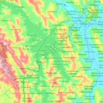
Name: Lake Bunyonyi topographic map, elevation, terrain.
Location: Lake Bunyonyi, Kabale, Western Region, Uganda (-1.40120 29.82351 -1.21260 29.96789)
Average elevation: 2,047 m
Minimum elevation: 1,785 m
Maximum elevation: 2,574 m
Other topographic maps
Click on a map to view its topography, its elevation and its terrain.