
Redondelo topographic map
Interactive map
Click on the map to display elevation.
About this map
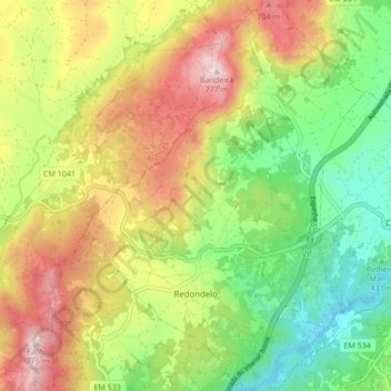
Name: Redondelo topographic map, elevation, terrain.
Location: Redondelo, Chaves, Vila Real, 5400-727, Portugal (41.68814 -7.59229 41.75167 -7.53159)
Average elevation: 522 m
Minimum elevation: 326 m
Maximum elevation: 773 m
Other topographic maps
Click on a map to view its topography, its elevation and its terrain.
Vidago (União das freguesias de Vidago, Arcossó, Selhariz e Vilarinho das Paranheiras)
Vidago (União das freguesias de Vidago, Arcossó, Selhariz e Vilarinho das Paranheiras), Chaves, Vila Real, Portugal
Average elevation: 444 m