
Sanfins topographic map
Interactive map
Click on the map to display elevation.
About this map
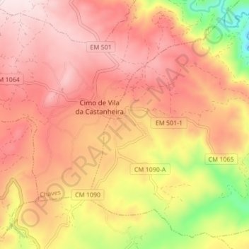
Name: Sanfins topographic map, elevation, terrain.
Location: Sanfins, Chaves, Vila Real, Portugal (41.76819 -7.26143 41.81430 -7.19295)
Average elevation: 731 m
Minimum elevation: 420 m
Maximum elevation: 912 m
Other topographic maps
Click on a map to view its topography, its elevation and its terrain.
Vidago (União das freguesias de Vidago, Arcossó, Selhariz e Vilarinho das Paranheiras)
Vidago (União das freguesias de Vidago, Arcossó, Selhariz e Vilarinho das Paranheiras), Chaves, Vila Real, Portugal
Average elevation: 444 m