
East topographic map
Interactive map
Click on the map to display elevation.
About this map
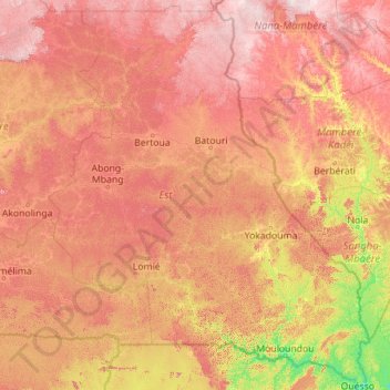
Name: East topographic map, elevation, terrain.
Location: East, Cameroon (1.65179 12.49414 6.12910 16.19110)
Average elevation: 643 m
Minimum elevation: 330 m
Maximum elevation: 1,149 m
Almost the entire territory of the East Region lies on the South Cameroon Plateau that forms the southeastern half of the country. The elevation thus varies between 500 and 1000 metres above sea level except for lower-lying plains of 200 to 500 metres in the extreme southeast centered on the Dja, Boumba, Sangha, and Ngoko Rivers. The land consists largely of monotonous, gently undulating hills known as "half-oranges" due to their resemblance to that fruit.
Other topographic maps
Click on a map to view its topography, its elevation and its terrain.
Gang Gang
Cameroon > North > Mayo-Louti > Figuil
Gang Gang, Figuil, Mayo-Louti, North, Cameroon
Average elevation: 402 m
Biyem-Assi
Cameroon > Centre > Yaoundé VI
Biyem-Assi, Yaoundé VI, CUY, Mfoundi, Centre, Cameroon
Average elevation: 718 m
Ngaoundéré I
Cameroon > Adamawa > Vina > Ngaoundéré I
Ngaoundéré I, Communauté urbaine de Ngaoundéré, Vina, Adamawa, Cameroon
Average elevation: 1,106 m
Ikiliwindi Mile 12
Cameroon > Southwest > Meme > Kumba II > Ikiliwindi Mile 12
Ikiliwindi Mile 12, Kumba II, Communauté urbaine de Kumba, Meme, Southwest, Cameroon
Average elevation: 288 m
Mount Manenguba
Cameroon > Southwest > Kupe-Muanenguba > Bangem
Mount Manenguba, Bangem, Kupe-Muanenguba, Southwest, Cameroon
Average elevation: 2,112 m
Momo
Cameroon > Northwest > Widikum-Boffé
Momo, Widikum-Boffé, Momo, Northwest, Cameroon
Average elevation: 628 m
Yaoundé VI
Cameroon > Centre > Yaoundé VI
Yaoundé VI, CUY, Mfoundi, Centre, Cameroon
Average elevation: 731 m
Alantika Mountains
Alantika Mountains, Béka, Faro, North, Cameroon
Average elevation: 1,618 m
Mandara Mountains
Mandara Mountains, Koza, Mayo-Tsanaga, Far-North, Cameroon
Average elevation: 868 m