
Mount Claremont topographic map
Interactive map
Click on the map to display elevation.
About this map
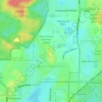
Name: Mount Claremont topographic map, elevation, terrain.
Average elevation: 23 m
Minimum elevation: 0 m
Maximum elevation: 75 m
Other topographic maps
Click on a map to view its topography, its elevation and its terrain.
Dalkeith
Australia > Western Australia > City of Nedlands
Dalkeith, City of Nedlands, Western Australia, Australia
Average elevation: 14 m
Nedlands
Australia > Western Australia > City of Nedlands
Nedlands, City of Nedlands, Western Australia, 6009, Australia
Average elevation: 20 m
Allen Park Bushland
Australia > Western Australia > City of Nedlands
Allen Park Bushland, Swanbourne, City of Nedlands, Western Australia, 6910, Australia
Average elevation: 15 m