
Pompeys Pillar topographic map
Interactive map
Click on the map to display elevation.
About this map
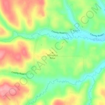
Name: Pompeys Pillar topographic map, elevation, terrain.
Location: Pompeys Pillar, Iowa County, Wisconsin, USA (43.07727 -90.31110 43.07737 -90.31100)
Average elevation: 284 m
Minimum elevation: 234 m
Maximum elevation: 341 m
Other topographic maps
Click on a map to view its topography, its elevation and its terrain.
Brookfield
USA > Wisconsin > Brookfield
Brookfield, Waukesha County, Wisconsin, USA
Average elevation: 251 m
Sturgeon Bay
USA > Wisconsin > Sturgeon Bay
Sturgeon Bay, Door County, Wisconsin, 54235, USA
Average elevation: 199 m
Scandinavia
USA > Wisconsin > Scandinavia
Scandinavia, Waupaca County, Wisconsin, USA
Average elevation: 293 m
Rubicon River
Rubicon River, Hartford, Washington County, Wisconsin, 53027, USA
Average elevation: 312 m
New Richmond
USA > Wisconsin > New Richmond
New Richmond, Saint Croix County, Wisconsin, 54017-1733, USA
Average elevation: 304 m
Robbins Island
Robbins Island, Town of Florence, Florence County, Wisconsin, 52121, USA
Average elevation: 385 m
Pine River
Pine River, Town of Long Lake, Florence County, Wisconsin, 54121, USA
Average elevation: 460 m
Johnson Creek
Johnson Creek, Town of Stockbridge, Calumet County, Wisconsin, 53088, USA
Average elevation: 278 m
Avoca Lake
Avoca Lake, West Lakeshore Drive, Avoca, Iowa County, Wisconsin, 53506, USA
Average elevation: 212 m
Two Rivers
USA > Wisconsin > Two Rivers
Two Rivers, Manitowoc County, Wisconsin, USA
Average elevation: 180 m