
English Island topographic map
Interactive map
Click on the map to display elevation.
About this map
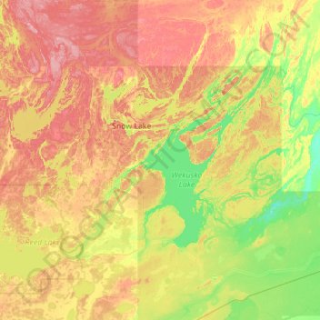
Name: English Island topographic map, elevation, terrain.
Location: English Island, Manitoba, Canada (54.49112 -100.24265 55.13112 -99.60265)
Average elevation: 285 m
Minimum elevation: 244 m
Maximum elevation: 343 m
Other topographic maps
Click on a map to view its topography, its elevation and its terrain.
Goulbourne
Canada > Manitoba > Division No. 18 > Municipality of West Interlake
Goulbourne, Municipality of West Interlake, Division No. 18, Manitoba, Canada
Average elevation: 251 m
Port Nelson
Canada > Manitoba > Division No. 23 > Unorganized Division No. 23
Port Nelson, Unorganized Division No. 23, Division No. 23, Manitoba, Canada
Average elevation: 9 m
Swan River
Canada > Manitoba > Swan River
Swan River, Manitoba, R0I 1Z0, Canada
Average elevation: 341 m
Darwin
Canada > Manitoba > Division No. 1 > Rural Municipality of Whitemouth
Darwin, Rural Municipality of Whitemouth, Division No. 1, Manitoba, Canada
Average elevation: 293 m
Cartwright
Canada > Manitoba > Cartwright
Cartwright, Manitoba, R0K 0L0, Canada
Average elevation: 465 m
Oakbank
Canada > Manitoba > Springfield > Oakbank
Oakbank, Springfield, Manitoba, R0E 1J2, Canada
Average elevation: 245 m
MacGregor
Canada > Manitoba > Division No. 8
MacGregor, Division No. 8, Manitoba, R0H 0R0, Canada
Average elevation: 293 m
Maple Grove Park
Maple Grove Park, Winnipeg, Winnipeg (city), Manitoba, R3T 2V9, Canada
Average elevation: 233 m
Greenway
Canada > Manitoba > Division No. 4 > Rural Municipality of Argyle
Greenway, Rural Municipality of Argyle, Division No. 4, Manitoba, Canada
Average elevation: 431 m
Portage La Prairie
Canada > Manitoba > Portage La Prairie
Portage La Prairie, Manitoba, Canada
Average elevation: 262 m
Deloraine
Canada > Manitoba > Division No. 5
Deloraine, Division No. 5, Manitoba, R0M 0M0, Canada
Average elevation: 500 m
Wallace Lake
Wallace Lake, Provincial Road 304, Manitoba, Canada
Average elevation: 314 m
Contour
Canada > Manitoba > Division No. 1 > Rural Municipality of Reynolds
Contour, Rural Municipality of Reynolds, Division No. 1, Manitoba, Canada
Average elevation: 299 m