Geolocate

Division No. 5 topographic map

Click on the map to display elevation.

About this map
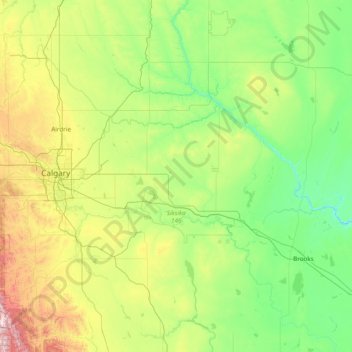
Name: Division No. 5 topographic map, elevation, terrain.

Location: Division No. 5, Alberta, Canada (50.04808 -113.73715 51.98290 -112.10745)

Average elevation: 944 m

Minimum elevation: 635 m

Maximum elevation: 2,519 m

Other topographic maps

Click on a map to view its topography, its elevation and its terrain.
Grovedale

Canada > Alberta > Division No. 18

Average elevation: 673 m

Moraine Lake

Canada > Alberta > Improvement District No. 9

Moraine Lake is a snow and glacially fed lake in Banff National Park, 14 kilometres (8.7 mi) outside the village of Lake Louise, Alberta, Canada. It is situated in the Valley of the Ten Peaks, at an elevation of approximately 1,884 metres (6,181 ft). The lake has a surface area of 50 hectares (120 acres).

Average elevation: 2,101 m
Cameron Falls

Canada > Alberta > Division No. 3

Average elevation: 1,469 m

Toronto Peak

Canada > Alberta > Division No. 15

Average elevation: 2,423 m

High River

Canada > Alberta > Town of High River

Average elevation: 1,042 m

Massive

Canada > Alberta > Division No. 15

Average elevation: 1,469 m

Ryley

Canada > Alberta > Village of Ryley > Ryley

Average elevation: 692 m

Mount Hector

Canada > Alberta > Improvement District No. 9

Average elevation: 2,710 m

Gear up for your next adventure:

🦘Outback Survival Gear - Essential gear for Australian outback
📟Satellite Messengers - Two-way satellite communication to stay in touch beyond the cellular grid
🪫Rechargeable Headlamps - USB rechargeable headlamps
🔋Solar Power Banks - Charge your phone and GPS using the sun while deep in the bush
🌿Flora and Fauna Field Guides - Identify the plants and animals you encounter on your route

As an Amazon Associate, this site earns from qualifying purchases at no extra cost to you.