
Río Mura topographic map
Interactive map
Click on the map to display elevation.
About this map
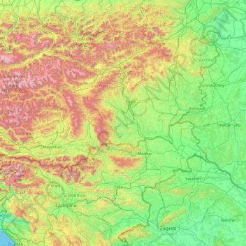
Name: Río Mura topographic map, elevation, terrain.
Location: Río Mura, Deutschlandsberg, Estiria, 5591.0, Austria (46.29770 13.34672 47.41324 16.88580)
Average elevation: 620 m
Minimum elevation: 0 m
Maximum elevation: 2,845 m
Other topographic maps
Click on a map to view its topography, its elevation and its terrain.
Gratwein-Straßengel
Austria > Estiria > Bezirk Graz-Umgebung
Gratwein-Straßengel, Bezirk Graz-Umgebung, Estiria, 8112, Austria
Average elevation: 576 m
Krast
Austria > Estiria > Bezirk Leibnitz > Oberhaag
Krast, Oberhaag, Bezirk Leibnitz, Estiria, 8455, Austria
Average elevation: 361 m
Gfangenbach
Gfangenbach, Hartl, Bezirk Hartberg-Fürstenfeld, Estiria, 8224, Austria
Average elevation: 358 m
Hoheneck
Austria > Estiria > Mautern in Steiermark
Hoheneck, Mautern in Steiermark, Leoben, Estiria, 8774, Austria
Average elevation: 1,270 m
Feldkirchen bei Graz
Austria > Estiria > Feldkirchen bei Graz
Feldkirchen bei Graz, Graz-Umgebung, Estiria, 8073, Austria
Average elevation: 335 m
Neusiedler Teich
Neusiedler Teich, Steinbachweg, Neusiedl, Hartl, Hartberg-Fürstenfeld, Estiria, 8264, Austria
Average elevation: 398 m
Knittelfeld
Austria > Estiria > Knittelfeld
Knittelfeld, Murtal, Estiria, 8720, Austria
Average elevation: 730 m